Establishment-AnointedOne: Whatcouldpossiblygowrong?
Fakery, Sacrilege, PseudoScience
Flagwaving: Academe's Moguls
Smithsonian Inst Maps' Fake Geography. Again.
Hitherto-Unrevealed Hayes MS Field-Record
Precisely Locating Hayes' Farthest
A Bad Tamper Can Get You in Trouble
Hayes' Scheme Unravelled: Addition & Subtraction
Fast-Shuffling the Capes That Never Were
The Actual Northernmost Marches
Re-Inventing the Calendar
Down for the Count
Restoration of Calendaric Reality
When Did Hayes Begin to Think Fraud?
Holding a Mirror to Polar Hayes: Revised Virgin
Dawn of the Dead-Reckoning
God's Advocate and Meridian Math
Port F-Up
He Knew Where He Was All Along. Was He Cluing Us?
What Was Not Said at Cape 8: Greenland's Invisibility
Holy Wholly Holey
Appendix: Hayes' 1861 May Locations and Observations
Reconstructive Strategy & Procedure
Illustrations [Maps, Manuscript Pages, Etc]
Tightly Linked Throughout Text
Among the most transparent of arctic exploration-exaggerators was politician-explorer Isaac Israel Hayes (1832-1881), whose present obscurity is one of the most fascinating, instructive, and Orwellian facets of the detective-mystery you are about to read.
No other arctic explorer was ever so unanimously — nay, flagrantly — endorsed by US academe and wealthy patriots. If ever there was an Establishment Arctic Explorer, Isaac Hayes was it. For over 1 1/2 decades (1857-1873), Isaac Hayes was universally considered the United States' leading arctic explorer and authority.
A veteran of the late martyred Elisha Kent Kane's 1853-1855 Greenland expedition in the ship Advance, Hayes assumed the halo left by Kane's 1857 death. And he shortly had convinced bigbuckbackers to fund an expedition of his own, in the subtly re-named ship: United States.
Following close upon the US' expansionist war with Mexico, the 1850s-1860s polar expeditions of Kane and Hayes can be interpreted as among the 1st symptoms of nascent US imperialism.
Describing his 1861 trip, Hayes claimed a record farthest north land, and (while evidently going for the Bulwer-Lytton Award for record-longest sentence of the 1860s) spoke ever so inspirationally of his emotions upon leaving his sacred [alleged] farthest-north-ever turf (HO351-352, preserving [as throughout here] Hayes' arcane punctuation):
I quit the place with reluctance. It possessed a fascination for me, and it was with no ordinary sensations that I contemplated my situation … in that hitherto untrodden desert; while my nearness to the earth's axis, the consciousness of standing upon land far beyond the limits of previous observation, the reflections which crossed my mind respecting the vast ocean which lay spread out before me, the thought that these ice-girdled waters might lash the shores of distant islands where dwell human beings of an unknown race, were circumstances calculated to invest the very air with mystery, to deepen the curiosity, and to strengthen the resolution to persevere in my determination to sail upon this sea and to explore its furthest limits; and as I recalled the struggles which had been made to reach this sea; — through the ice and across the ice, — by generations of brave men, it seemed as if the spirits of these Old Worthies came to encourage me, as their experience had already guided me; and I felt that I had within my grasp “the great and notable thing” which had inspired the zeal of sturdy [Martin] Frobrisher [sic], and that I had achieved the hope of matchless [Wm] Parry.
Unfortunately, Hayes prose-purpularity ascended
far higher than his latitude.
His farthest was a conscious fraud.
As will be variously demonstrated below, beyond the slightest doubt.
Hayes' 1860/7/7 departure for the arctic was blessed by
every relevant US academic society.
(An extensive list is provided here.)
The president of Harvard was at
the wharf in person. With such certifications,
how-could-anything-go-wrong?
[More seriously: if anything did go wrong
— would anyone ever know how wrong?]
The only catch was that, amidst the classic coagulative suckup-rush to get
behind and in-good-with the hero anointed by the political moguls
who controlled exploration-funding, no one had bothered to investigate
little matters like:
[a] whether Hayes knew navigation,
and
[b] whether he was an honest person — e.g., whether he had
(as persistent rumors were claiming) secretly mutinied against Kane in 1854
(an executable offense) and later
conspired to lie about it.
[The able Kane expedition member, Johan Carl Christian Petersen
of Denmark, highly expert at every aspect of arctic survival
(Geo.Corner Dr.Kane of the Arctic Seas Temple Univ 1972 p.132)
told the truth. (Prof. Oscar Villarejo's Dr.Kane's Voyage to the
Polar Lands [UPa 1965] is primarily based upon Petersen's
account of the mutiny.) Which proved — in case
his foreign-ness was not sufficient in itself — that
Petersen was unqualified to lead a US polar expedition.
(Spain's Ferdinand&Isabella were not famous for tolerance, but even
they didn't mind sending an Italian across the Atlantic in 1492.
Granted, nothing much came of the idea….)]
The funniest thing mutineer Hayes ever said (HO318; 1861/4/27),
fully worthy of
DIO's Doubletakes column:
“My men have failed me …
as those of Dr.Kane did before me.”
[Disbelieving that there was a mutiny, Amer Philos Soc chief
Geo. Corner (1972 p.290) attacks his colleague and Kane-history predecessor
Villarejo for erroneously charging that the official USS Advance ship's
“log” (Hist. Soc. Pa. archives)
of the expedition was mutilated (to hide the Kane mutiny) — declaring
instead (Corner pp.278 & 290 vs. Villarejo 1965 pp.25f & 172f)
that the supposedly destroyed section is simply part 1 of the Kane
“journal” (second part at Stanford Univ archives),
and thus that Villarejo had erred on whether there was a hidden mutiny.
But it is Corner who has erred. (DIO thanks Stanford archivist
Patricia Palmer for verifying this by direct examination,
and for sending photocopies of the disputed records.)
A close examination leaves no doubt that Villarejo was correct
(the log and journal are utterly different,
as a comparison of the 1855/5/1 entries will readily show),
and thus that the chief of the most venerable US academic institution
falsely denigrated the valid work of a fellow dedicated Kane historian.
Not that Corner ever had the integrity to publicly admit it.
(DIO's publisher was told several falsehoods by Corner
in connection with his bowdlerization
of a paper which he feared would upset the National Geographic Society.)
As for whether the Hayes-Sonntag defection was mutinous:
Villarejo was a colleague of several admirals in the U.S.Navy
and knew perfectly well what constituted a mutiny.]
Upon his return, hero Hayes went forth to thrill
a super-patriotic nation (NYTimes 1861/11/15:3:1):
“The land was taken possession of in the name of the United States
[DIO: though the states were rather
less than “united” at the time],
and the flag which was used on the occasion has covered the most
northern known land upon the globe. [Prolonged applause.]”
But the war diverted attention. And, as time passed,
it gradually (culminating in
1873) became apparent
to the mestablishment's aghast
ultra-socialites that the explorer they'd in 1860 lauded, funded, fan-fared,
and ceremonially seen-off to reach the North Pole, had instead
led a disastrous expedition by any measure (science or latitude-record)
and had perpetrated a fake farthest-north-land claim,
adorned with altered dates, north latitudes never remotely attained,
inventions of non-existent geography (fantasy bay, capes, peak,
Open Polar Sea, etc), even corruption of (his own) pre-existent geography
— all to set up a false claim to have found
the northern-most land on Earth.
Why? Frankly: to make a buck.
(His arctic-predecessor-martyr
and former colleague Kane had [Corner 1972 pp.237f] gleaned a fortune
with his hit 1856 best-seller
on his 1853-1855 expedition.)
[This wouldn't be
a unique instance of an arctic explorer lying for gain. But Hayes was
the hardy pioneer of what ultimately became a durable tradition.]
Because Hayes hid his sins and destroyed his diary, it has generally been
believed that his 1861 farthest-north point was an insoluble mystery.
E.g., even so able an explorer as
Sir Wally Herbert Noose of Laurels 1989 Chap.4:
“How far Hayes went
no one now will ever know”.
However, in what follows, we will discover
that long-elusive point
to remarkable precision: within ordmag 100 meters.
Upon realizing they'd been snookered,
the very same mestablishment-press combine
(which had foisted Hayes upon the community of genuine scientists)
conspired to protect its own rep for judicious
trust-worthiness — by betraying the
scientific community's and the public's trust:
covering up Hayes' sins, just letting him
(and thus its own folly) fade quietly down history's
memory-hole.
[Reminds one of how corporations prefer to handle embezzlers found
in their midst: nothing said publicly, just a smooth divorce —
on the quiet, to keep the firm's reputation from being damaged.
Such priorities are obviously selfishly dangerous,
since the perp is then passed on to his next victim as blemish-less.
The Hayes case well illustrates
the point: AGS-backed Kane's assent to hushing-up
the 1854 Hayes-Sonntag-etc mutiny handed Hayes to the AGS
as a seemingly ideal next US polar hero.]
It is one of the purposes of the present paper to undo that
all-too-typical exercise in
institutional dishonesty.
[Not the last time that one institutional polar cover-up led directly
to the need for yet another.
See below:
the Cook-Peary-Byrd triple-hoax chain (explained at
DIO 10 [2000]
pp.4-5.]
[In what follows, Hayes' 1867 book The Open Polar Sea
will be abbreviated “HO” so that page x will be
written as “HOx”. His original ms record,
“Bearings” (American Geographical Society archives),
will be similarly abbreviated, so that page z in it will be
referred to as “HBz”.
We will generally measure distance in nautical miles
(15% larger than statute miles), abbreviated “nmi”;
so 1nmi corresponds to 1' of great-circle distance
on the Earth's surface. A degree of latitude equals 60' or 60nmi.
But a degree (or 60') of longitude equals only c.10nmi near 80°N,
the approximate latitude we will be visiting below.
For the actual geographical coordinates of sites, capes, camps, etc, Yahoo
was adopted here as the most trustworthy of the various internet maps,
since its latitude (& NASA's) for Cape Jesup (83°38'N) closely matched
the real latitude of that well-measured spot, the northernmost coast on Earth,
discovered by the greatest US arctic explorer, Robert Peary 1900/5/13.
However, there is no guarantee
that the Yahoo maps do not contain small but non-trivial systematic errors.
The various internet maps disagree
with each other by ordmag 0'.1 (gt-circ) in the region of
the globe we will be investigating below.
Note: if these contain common errors, the accuracy could be worse than that.]
The enormity and sacrilege of Hayes' imposture is best précised by his own lying boast (HO374-375):
With [Sir Edward Parry, who in 1827 reached record-latitude 82°3/4 N over sea-ice north of Spitzbergen] I will now divide the honors of extreme northern travel; for, if he has carried the British flag upon the sea nearer to the North Pole than any flag had been carried hitherto, I have planted the American flag further north upon the land then [sic] any flag has been planted before.
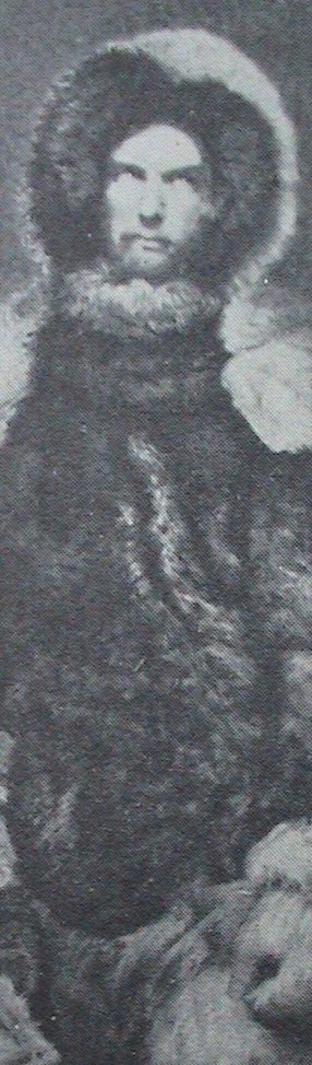
Hayes seemingly had all the attributes that mattered. An Ivy League M.D. (UPenn) and pioneer 1854 Ellesmere explorer with the Advance Expedition (1853-1855) of Elisha Kent Kane (another Philadelphia-area M.D.-explorer), he was: an inheritor of the glorified Kane's mantle, on the American Geographical Society's Council (see John Wright's centenary history of the AGS 1851-1951 [1952] p.52), Smithsonian lecturer (HO5), and a genuinely durable traveller (as was fellow faker F.Cook), who'd lost some of his toes to frostbite (Villarejo 1965 p.148) — among myriad other sufferings, sacrifices, awful disappointments, and wearingly strenuous & dangerous strivings (e.g., HO301, 366, & 369) in the service of exploration and ambition. (He is sometimes referred to as the 1st non-Eskimo to set foot on Ellesmere Island.) His false reports are all the more tragic because he possessed above-average if not extreme shares of intelligence, skills, and admirable qualities.
If one accepts the 1861 story he told, Hayes was apparently
an amateur — both technically
and conceptually,
regarding serious mathematical navigation.
[By contrast, such achieving and heroic explorers as Peary, Amundsen,
& R.Scott
were adept at the use of spherical trig-based navigation.
Note: If Hayes' bumbling 1861 yarn that his watch stopped accidentally
were true, he was obviously an amateur in being unable to effect remedy.
But its falsity (which will be established below)
is far more indicting, since his patched-together & inconsistent tale
(meant to alibi-cover
for his exaggerated north-latitude claim)
is even bumblier,
thus hardly a credit to his science or cleverness.]
Unfortunately, such trivia mattered far less than Hayes' high political associations and skills. Even in remote Greenland in 1860, he still had the touch, setting out for the Upernavik locals a formal meal (HO41-42)
to the representatives of King Frederick the Seventh, at this most northern outpost of Christian settlement. Accordingly I sent my secretary, Mr.Knorr, out with some formal-looking invitations, gotten up in all the dignity of Parisian paper and rose-scented wax. … clean white table-cloth …. noble salmon — an excellent punch from Santa Cruz….
And Hayes' mutinous history was unknown because of a previous cover-up as air-tight as the one that later protected the public from knowing what fools Hayes had ultimately made of all his ultra-eminent backers.
Both Kane and (much more so) Hayes exaggerated their latitudes to claim
new farthest-north-land-reached records,
launching a trend in US polar fakery that
ultimately culminated in
the 1908-1926 already-cited
triple-hoax chain of Cook-Peary-Byrd.
Adding Kane and Hayes to the more famous case of Frederick Cook, M.D.,
we have the extraordinary spectacle that the three clumsiest fabricators
in US arctic history were all M.D.s (a point we will
return to)
— which doesn't say much for antique US medical ethics.
[Additionally, there is the case of Hayes' own
thieving doctor.
Note: back in the era when a general practitioner's ministrations were
as likely to harm as help his patients, perhaps
bedside-manner-bluff was the prime key to success in the field.]
It is also enlightening to note that the only one of the three ever attacked
(e.g., Geographical Review (AGS) 5:140-141,
43:129-130) in US geographical journals was also
the only one who publicly criticized the societies. (See, e.g., F.Cook
My Attainment of the Pole 1911&1913 pp.543-544.)
After his service with (and mutinous betrayal of) Kane,
Hayes then headed his own expedition (1860-1861), aiming to cross
straight to the North Pole, via the mythical “Open Polar Sea”,
supposedly semi-verified by Kane's 1853-1855 expedition.
(The idea of an open polar sea long [Corner 1972 pp.108-109]
pre-dated Kane & Hayes, whose alleged sightings were merely feeding
the prejudices of moguls who already
believed in it.) Note the clarity of Hayes' intentions as revealed by
letterings on the map published with his 1860 book,
An Arctic Boat Journey.
[Which told the story of the 1854 Kane Mutiny.
Was the 1954 H.Wouk novel's title, Caine Mutiny, a hint
that Wouk knew who played intolerable Queeg in the only USNavy mutiny?
But, unlike Wouk, Hayes left out
the mutiny part.
James Cook-protégé Capt. Ned Bligh
(on whose greatness as a navigator, see
C.Nordhoff & J.Hall Men Against the Sea 1934),
was an earlier (1789) object of a mutiny, this in the British navy.
Coincidence dep't: both mutinies took place shortly after seamen
mingled for months with a people of looser, more hedonistic mores than
those of WASP civilization. DR will typically endear himself to
PC anthropologists by commenting that his 1996 March visit to Tahiti
impressed upon him the unlikelihood of anyone achieving much,
who has long lived amongst the natives of such civilizations.
Paul Gauguin is not an exception but indeed the perfect example.
Robert Louis Stevenson
comes nearest to providing the rule-proving exception.]
Probably the looniest item on the Hayes map
he published with his 1860 An Arctic Boat Journey is
his huge “Probable Northern limit of
the ice belt in the Summer”.
I.e., if you want cold, forget about the Arctic Ocean, and instead make for
the map's “Approximate American Pole of cold” in Canada,
the coldest spot in the American hemisphere, at about 78°N, 95°W.
Hayes even asserted that the Earth's cold pole was not the geographical but
the magnetic pole, and the Royal Geographical Society actually printed
this stuff. (Hayes 1858/5/23 letter, Proc Roy Geogr Soc 3:148.)
Keep in mind: this was the top US polar scientist in
the eyes of
the world scientific community's politicians for the next 15y.
(Indeed, it was the sci-fi just cited that got Hayes his backing.)
[As DIO readers are well aware, there are academic fields
today that exhibit
like acumen and priorities when gauging scholarly talent.
Generally speaking, science is happily no longer one of them.]
Never wanting in the patriotism dep't,
Hayes named his ship (a schooner formerly called Spring Hill):
the United States. (Re-named
so by an act of
Congress: Hayes 1861 p.151; HO8.)
He went north more unanimously and flag-wavingly
backed by US academic societies
than any arctic venture before or since. (Those of NYC, Philadelphia,
Boston, Washington. Baltimorean DR is happy to note that
the only major northeastern US cultural center having nothing whatever to do
with helping put over Hayes' fake was Baltimore.)
This included the blessing of the US' leading geographical figure,
Henry Grinnell (head of the young American Geographical Society of NY),
for whom he & Kane tried to claim&name northern Ellesmere Island.
(See on left of Hayes-Smithsonian map:
[Schott 1867 p.i opposite.] The name ultimately didn't stick.)
[An observation regarding the entire history of US polar exploring:
faking tended to occur more in connexion with privately-funded expeditions.
By contrast: despite its many deaths, the gov't-backed 1881-1884 U.S.Army
expedition under Adolphus Washington Greely produced accurate reports,
solid science, and new geography — including
the most undubitable
of all of polar history's Farthest-Norths (1882).]
Among other committees, academic societies, associated luminaries,
& (notably) publishers subscribing to or assisting Hayes' expedition
(listed at HOxi-xvi & 5-12 & Hayes,
Smithsonian Annual Report 1861:149-160 pp.149 & 157):
American Geographical Society (NYC): ultra-mogul of US geography Grinnell,
able astronomer (soon-to-be Major-General in the upcoming war)
Ormsby Mitchel, Harpers Bros, G.P.Putnam;
American Association for the Advancement of Science;
American Philosophical Society (US equiv of UK's Royal Society);
American Journal of Arts & Sciences (NYC);
Academy of Natural Sciences (Philad):
Childs & Peterson, J.B.Lippincott & Co,
A.Bache (US Coast & Geodetic Survey head);
top US scientist Jos.Henry
(Smithsonian Institution head);
Academy of Arts & Sciences (Boston): Louis Agassiz (Harvard),
Benj.A.Gould (founder of the still deservedly prominent
Astronomical Journal), for
whom Hayes named
[Gould Bay] (HO336n1), Edward Everett (top US academic of
the day [i.e., automatically doomed to be as forgotten as
Izzy Bowman]),
even the marvelous Nathaniel Bowditch.
Boston Society of Natural History;
Academy of Natural Sciences of Philadelphia.
And: The Bible Society
The ship was fêted in Boston harbor on its scheduled departure-date, 1860's Independence Day — a touch of patriotism that has been blamed for causing the ship to arrive in the north too late in the Summer for breaking through to the Arctic Ocean, beyond Smith Sound. The July Fourth speakers included (HO12) Harvard's president & the Governor of Massachusetts, among other “renowned statesmen, orators, divines and merchants of Boston, and by savans of Cambridge [Harvard]”. After 3 more days of delay, the ship finally sailed on 1860/7/7 (HO13).
The Hayes expedition resulted in the most disgracefully bungled arctic chart
in the history of US science. Click link
to view the Smithsonian Institution's 1865 map
of Hayes' fantastic alleged 1861 explorations and discoveries
on Ellesmere (north Canada). (Charles Anthony Schott,
Smithsonian Contributions to Knowledge #196 [1867]
Physical Observations in the Arctic Seas by Isaac I. Hayes.)
[It was perhaps the eventual awareness of Hayes' unreliability
that educated the AGS: note that it never for a moment fell
(as National Geographic eagerly did) for the later
fake N.Pole claims of able engineer Peary (1909)
and able politician Byrd (1926),
who had been a congressional lobbyist before he became a polar hero
(DIO 10 [2000]
§B7 [p.16]), even while justly and generously honoring both explorers
with AGS medals for their considerable genuine polar contributions:
1898-1902 and 1929-1930, resp.]
It will be instructive to compare Hayes' map with Kane's,
as rendered by the same USC&GS astronomer, Chas. Schott in 1860,
so we provide the Kane map, too.
Given that the actual east coast of Ellesmere trends
far more northeastward, it is immediately obvious that Hayes
(in the Hayes-Schott map or opp HO72) has largely copied
Kane's coastline
— including its dominant errors. A plagiarist's nightmare.
[Note that in the later Hayes map,
Cape Louis Napoleon
has been moved to replace Cape Prescott. In the Kane-Schott
map, the Ellesmere (“Grinnell Land”) capes
up to Cape Frazer (spelled “Fraser” today)
are Hayes' 1854 May discoveries. Those beyond
Cape John Barrow
are based upon Kane steward-valet Wm.Morton's 1854/6/24 sightings
(with Eskimo Hans)
and thus are based merely upon guesstimates of the positions
of far-off lands, the most northern being those only
barely seen from Greenland's Cape Constitution (80°.6 N, 67°W),
itself grossly mismapped (see Schott 1860 chart) at 81°N, 66°W.
(Kane initially put it at 81°22'N
or even higher, 81°44'N; see Rawlins 1973 p.22.) Thus, the very base-point
of the northern Morton sightings was seriously in error.
Morton being Kane's valet, it is an oddity that
the sole non-Eskimo witnesses to both the 1854 & 1861
exaggerated farthest-norths were the personal servants
of the expedition leaders: Kane's W.Morton & Hayes' G.Knorr, resp.
This tradition was later extended by Peary's man, Matt Henson,
for Peary's 1906 & 1909 faked latitudes.
The Morton claim of farthest-north-land-trod is still widely believed,
though it is possible that in 1773 Constantine Phipps and even (young)
Horatio Nelson set foot on Spitzbergen-area land that was further north.
(North of Spitzbergen, the Phipps expedition sailed to 80°48'N.)
And returning members of the E.Parry 1827 expedition
(which got to 82°3/4 N over the ice north of Spitzbergen) probably
stood on land further north than Morton's 80°.6 N.]
During his remotest 1861 travels (5/14-18), Hayes got only about
20 nautical miles north of his 1854 farthest-north point,
Cape Frazer.
[Here, throughout (unless otherwise noted), references to
geographical capes, bays, lands, etc will refer to modern appellations.
Comparing the Hayes-Smithsonian chart
to a modern map will shock any reader — not
only at the audacious degree and folly of Hayes' fraud but at the extent to
which the science establishment put aside even international competitiveness
to paper-over his deceits
by retaining many of the names of Hayes' wildly mis-located
or never-seen capes etc, while shifting
them (sometime amusingly) far out of their originally mapped positions.
Wryly commenting upon such
mis-geography
is early Hayes-disbeliever Greely (1886 1:73 on Hayes' Carl Ritter
“Bay”): the agreeable mapping by the 1875-1876 Brit expedition
under George Nares (who saw through both Hayes & Cook)
of “the indentation at that point [81°.9 N on Ellesmere's east
coast] as a bay would seem to be a courtesy on the part of our English cousins
toward Dr.Hayes, who located there
[see Hayes-Smithsonian map]
an inlet some twenty-five miles deep. The actual indentation is so slight,
and the curve so great, that it is a bight rather than a bay.”
(In 1909, expert navigator [now Admiral-Sir-George] Nares, whose maps
[of the region that Kane & Hayes had messed up] were highly competent,
summed up the N.Pole claim of Cook — a doctor, backed by gambling-den
proprietor J.Bradley — with
incomparable contempt: it must be “either an American gambling scheme
to make money or a medical project to test the stupidity of the public.”
See Rawlins 1973 p.200.)]
Cape Frazer had been Hayes' genuine and well-mapped
discovery, made on 1854/5/27-28. (Mis-printed on the Hayes-Smithsonian
chart as 1854/5/8.)
But in 1861 he stretched his 1861/5/14-17 advance of c.20nmi beyond
Cape Frazer into over one hundred nautical miles
— map-displaying
Kane's long fantasy Canadian coast running virtually north-south
(merely 12°-15° E
of north, whereas the real Kennedy Channel runs
about 30°-35° E
of north): “Grinnell Land”.
[The error can be largely explained by the 18° error
in Hayes' chronometer. (But it is remarkable that Kane's map
should make much the same error years before Hayes' watch stopped!)
Of course, Hayes (unlike Morton in 1854) never in his life got
into Kennedy Channel at all; but he did get
a roughly accurate azimuth
— as seen from Cape Collinson
— of Cape Lawrence,
the western of Kennedy Channel's southern portals. Thus, despite the false
(nearly N-S) direction
of the coast from Cape Frazer
to Cape Collinson,
Schott was enabled to get a pretty good idea of
the off-north slant of Kennedy Channel as seen from
Cape Collinson.
By contrast, Hayes' own map (opp HO72) has the same slant way more
nearly due north (only c.15° east of), which is consistent with
his erroneous watch, but conflicts
with his own computed true azimuth.]
“Grinnell Land” is displayed to the left (west) of Kennedy Channel
in the chart. Hayes placed his alleged 1861
farthest-north-land-reached right on the Ellesmere (“Grinnell”)
east coast at latitude 81°35'N, longitude 70°30'W —
barely exceeding the Kane expedition's own exaggerated claim of having
reached 81°22'N on 1854/6/24.
[Hayes asserted that Morton in 1854 didn't get past 80°56'N,
the exaggerated latitude shown on the Kane-Schott map.
(See Hayes 1858 p.147 and NYTimes 1861/11/15:3:1.)
But Hayes reported his own claimed 1861 latitude just high enough that
it was #1, no matter the prevailing opinion on Kane-Morton.
So the ambiguity regarding Morton's highest latitude
probably forced the Hayes exaggeration's ultra-ludicrousness
(80°07'N reported as 81°35'N)
— a way-overdone stretch-try at putting beyond dispute that
he had achieved the highest latitude ever on land. This leap-frogging
fabrication-farce was finally cut short by the accurate 1871-1882 work of
the US' Hall, Brits Nares-A.Markham-Beaumont-Aldrich,
and the US' Greely-Lockwood.]
But the spot at the given geographical coordinates is deep-inland
not coastal — which is a prime reason why none of his latitude
claims are now taken seriously by anyone.
[By far the best modern account of Hayes' 1860-1861 expedition —
and the genuine agonies he endured during it — is that of Canadian
historian Pierre Berton Arctic Grail 1988 Chap.9 Pt.2.
Note that we are not covering here Hayes' 1854 & 1861 crossings
of the hummock-packed Kane Basin, from Greenland to Ellesmere & back.
He compares the ice-chaos he met (see illustration opp. HO322)
to “a thousand Lisbons crowded together
and tumbled to pieces by the shock of [a meta] earthquake” [HO312]
and despairs [HO314] of the impression that he must travel 5mi to make 1mi
of northing. Do not fail to realize that this was the worst of his travails.]
Nonetheless, the questions remain:
[a] Is there an innocent explanation?
[b] Did he merely miscalculate? — as some have suggested.
[c] Did he commit fraud?
[d] Did he fake his farthest north Sun-sight sextant datum?
Our respective answers below will be:
[a] At the outset, yes — in part.
[b] No. [How many polarward arctic explorers ever accidently deludedly
misplaced themselves south of where they actually were?]
[c] Yes.
[d] Yes.
The crucial portion (1861/4/10-5/29) of the relevant diary is
conveniently lost. But decades ago DR consulted,
via the expert assistance (1971/9/20) of AGS Librarian Lynn S. Mullins,
Hayes' 1861 survey-book, “Bearings”. (As noted earlier,
this ms will here be abbreviated as just “HB”.)
[HB is item#8 of the AGS holdings of Hayes material.
The AGS archival list calls it “copied from field notes” —
but it has all the earmarks of an original field document.
But he may well have copied material into HB. After all, if he had
a field-journal (HB) called “Bearings”
(for [mostly time-independent] compass azimuthal data), wouldn't he have
a companion called “Altitudes” for recording sextant data
and their times, for finding latitude and longitude?
Note: all HB's altitude sextant look (see reproductions here) as if they were
not in the original HB but were taken from “Altitudes” were
later just tucked
into blank spots Hayes found here&there on HB's pages: virtually all
sextant data in HB are at the bottom of a page,
and not always chronologically quite right.
(This may also be true of compass variation observations:
HB22&38, Schott p.86.)
Among the mix-ups on HB40 is a suggestion of mis-copied material.)
This point and the subsequent disappearance of the “Altitudes”
journal suggest that all altitude sextant data in HB are non-primary.
They were selectively copied from “Altitudes” into HB
before he disappeared the original “Altitudes” journal.
Thus, HB is the sole known ms relic of his 1861 Ellesmere trip.]
This material permitted DR's solution of Hayes' actual whereabouts on
1861/5/17, and below reconstruction
in detail of Hayes' entire Ellesmere adventure.
As announced for the 1st time in
Rawlins Peary at the North Pole; Fact or Fiction? [1973] p.25,
Hayes' true 1861/5/17 farthest north was Cape Collinson
(Ellesmere Island, Canada),
barely past 80°N.
Later-claimed latitude: 81°35'N.
[For the claim
of farthest-north-land-reached at 81°35'N.,
see New York Times 1861/10/11 pp.4&9 or
Isaac Israel Hayes The Open Polar Sea (HO) 1867
HO351 — a book which (Rawlins 1973 p.24) got Hayes
the gold medal
of the Royal Geographical Society. Just in time.
Hall's expedition was the 1st to see
(1871) that Hayes that had invented the geography of east Ellesmere,
and the Hall survivors reached civilization in
1873.
After departing his Greenland base-camp
(“Port Foulke” 78°17'.4 N, 72°38'.6 W,
about 2nmi from the well known Eskimo village of Etah), and crossing
the Kane Basin's ice-hummocks — shedding some men en-route —
on a path virtually due north (presumably by compass-course,
if his chronometer was already off, as he indicated),
he and 3 companions (dog-manager [HO40] Peter Jensen, seaman [HO10]
John McDonald, and Hayes' sec'y [HO10&41] Geo.Knorr) reached Canada
on 1861/5/11 near Ellesmere's Cape Hawks
(79°32'N, 73°W).
 [On the left find a narrow map of the Ellesmere coast from
Cape Hawks (bottom)
to Cape Lawrence (top), the latter being Hayes' eventual
furthest-north-land-seen.
[On the left find a narrow map of the Ellesmere coast from
Cape Hawks (bottom)
to Cape Lawrence (top), the latter being Hayes' eventual
furthest-north-land-seen.
Every major point on the coast will, when cited in the text,
be glowing with a link such that clicking on it will swiftly bring up the map
— and (assuming reader's use of full screen-width)
the clicked coastal feature will appear
(on the map's coast) nearly at the top of the reader's screen.
On the map, Up = nearly northeast, since this is a 45°-tilted
piece of one of several splices
(more below)
which DIO's Keith Pickering has accomplished from
Geological Survey of Canada color topographical (“topo”) maps.
Details
regarding all these maps (including the present one)
are found below.]
The Hayes party then sledged along a coast that trended somewhat
east of north-east at first (until
he rounds Cape Frazer).
Hayes' 1st (Sun-sight
(Table 2 below) on Canadian soil
since
1854 was taken on 1861/5/13 at what
he called “Foggy Camp”:
a double-altitude via pocket sextant (Gilbert's #3 [Schott 1867 p.20n]),
with mercury (Hg) reflecting artificial horizon.
[This he estimated was c.1/4 mi
SW of Point Joy.
(Though Hayes' distance
estimates are usually exaggerated.)
See the tiny triangle near that feature on the Hayes-Smithsonian
map. (Schott misplaces the camp SE of Pt.Joy.
The original HB23 sketch makes it SW.)]
It was a longitude observation. Which should have instantly
clued him to the fact that there was a huge error
in his allegedly lone
pocket chronometer.
[The compass' direction
at chronometer-“noon” had also
not already given him analogous pause: a virtually
(perhaps really) — incredible symptom of
apparent navigational
obtuseness.
Hayes alibi-comments on such matters in his book's preface (HOviii)
provide yet another
example of his acting as prototype for F.Cook:
“entire accuracy was not attainable in the field, inasmuch as I had
neither the leisure nor the facilities for reducing the magnetic [compass]
variation, nor for obtaining
the absolute time.”
What an ideal choice to lead an expedition universally
backed by US scientific societies!]
Shades of R.Byrd's 1926 N.Pole hoax, which crucially exploited
the ludicrous claim that he had carried but one sextant
on his journey, and (a-là Hayes'
non-winding his watch)
it “broke” during the trip.
This, though Byrd is known to have carried multiples
of every other portable navigation-related instrument. See
DIO 10 [2000]
end-note 8 pp.91-92.]
[A conventional sextant time-check by Hayes would have required
spherical trig.]
On 5/14, the party passed Cape Frazer (78°3/4 N, 71°W), his farthest north in 1854, camping just NE of there, at 78°47'N, 71°.1 W, where he took a latitude observation that disagreed seriously with the latitude he'd obtained for the same spot in 1854. Proceeding in a more northerly direction than previously, the explorers camped the next day (5/15) at what Hayes privately called “Tired Dogs Camp” (HB25&34), suggesting transport problems. Before crossing Scoresby Bay, he realized all his men were worn out (HO342), so he left the injured Jensen, his strongest man (HO342-343) and dog-manager, with McDonald on the bay's south shore (on the north shore of what is now called Cape Knorr: see above-left Canadian GPS Survey topographical map), telling McDonald (HO343) that he expected to be back within 5 days. He then struck northward with only his sec'y Geo.Knorr as companion. By 5/16, matters had worsened to “Bewildered Camp” (HB27).
On 5/16-17, they cleared 80°N, which extremely few other Europeans had
done up to that time. (Eskimos may've. Hayes found traces of Eskimo camps
near 80°N: see, e.g., HO337&341
and the Hayes-Schott map.
Morton had, too, virtually at his 1854 farthest: Kane 1856 2:377.
Hayes took compass bearings of northern capes as seen from
the southern part of the east coast of Cape Collinson
(at a place we'll later see was Hayes' Cape 10):
80°02'N, 70°.5 W.
Low on hale men&dogs, short on provisions, rightly fearing that melting
ice would lengthen bay-crossing times (esp. the Kane Basin return's), a tired
and bitterly disappointed Hayes was forced to make his last camp there.
According to the innocent-error theory of the expedition (which we will
ultimately argue was deliberately staged by Hayes):
after a “noon” sextant shot of the Sun at (see
Table 1) about 36m past his slow-chronometer-noon
(an impropriety — possibly
from variable weather [and perhaps not] — which he may (if we assume
— contra strong evidence —
that he still didn't know correct time) initially
have regarded as minor),
Hayes started at 2PM by his watch (HB31),
towards the northern part of Cape Collinson
(see topo and Cape 11 on HB31):
80°07'N, 70°.5 W.
He claims he found by trial that (what is now called)
John Richardson Bay was impassible due to unsafe ice.
He then (HB31) returned to the last camp, lunched,
“Displayed flags”, and headed south.
(Hayes considered naming the bay “United States Bay”:
see HB28. It was eventually instead identified
with Kane-Morton's far-off-seen (1854) Lady Franklin Bay
placing it at c.81°3/4 N.)
[See both the Kane-Schott
and the Hayes-Schott Smithsonian maps.
Curiously, Captain Edw.Inglefield (the 1852 discoverer of Ellesmere Island)
had placed a “Lady Franklin Bay” on the east side of
Smith Sound, on the west coast of Greenland in the 79th degree of latitude.]
When later explorers found a bay at roughly the Kane-Hayes latitude-guess
(though far different longitude), they called it:
Lady Franklin Bay.
[Consider the resultant oddity that Greely's 1881-1884 expedition
in that region became known as the “Lady Franklin Bay Expedition”,
thus acquiring its name from the false Kane-Morton-Hayes reports;
yet Greely's was a geographically honest and highly productive endeavor,
which achieved history's
most impregnable Farthest-North claim, in Greenland (83°24'N, 41°W),
reached on 1882/5/13 by Greely's James Lockwood. (A genuine arctic martyr, who
died in the north and is buried beneath an imaginatively rendered tombstone
at the US Naval Academy: a ruled solid globe whose axis is tilted 83°24'.)
His cairn-record was later recovered
by, ironically, Greely's most undeterrable detractor, Rob't Peary.
(Rawlins 1973 p.29.)]
Rawlins Peary Fiction [1973] p.25 found Hayes' 1861/5/17
farthest position initially by counting deep-indentation-bays-crossed in HB.
(Hayes' published map shows
2 such bays, each miles-wide,
between Cape Frazer & farthest. But HB shows only one.
Note Greely's comment, above.)
[Hayes was an able artist. And not just at the con.
In addition to his ability to draw scenes,
he sketch-mapped the coasts he visited, reasonably-well converting
— and entering onto HB8's pages —
his horizontal experiences, in series of seen-from-above maps
which we will henceforth below call his ``coastal maps''.
He was also an engaging writer,
whose works signify a person of reflectivity, sympathy,
and some humor.]
But the Cape Collinson solution
is further iced-confirmed by Hayes' set of
compass-bearings (augmented by HB28's excellent
labelled scene-sketch) taken on 1861/5/17 from HB's
Cape 10
(80°02'N, 70°.5 W, on the southern part
of Cape Collinson's easterly extension).
The sign-less bearing-data
(HB28) were measured
with respect to compass-south
(the true azimuth of which was
c.70°),
where we include in brackets Hayes' own politically-canny names
for these capes (which he sets out at HO372-374, mapping them opp. HO72).
[Does the repeated kissing-up to
foreign biggies (which we're about to see here, below) hint that
Hayes' claims were becoming suspect
in the US even before 1st hand witnesses' dis-confirmations arrived back
from the arctic in 1873?
(No foreign-name suggestions appear in HB.)
Hayes was still internationally pristine at least as late as
1867.
But, after 1873, when Hall-expedition members began returning home,
it was all downhill for Hall's long-time nemesis Hayes.
The long-delayed moment of truth is recorded, live, in
Hall expedition survivor G.Tyson's diary (G.Tyson & E.Blake
… Drift … 1874 p.148) for 1871/8/28,
in Kennedy Channel (moving northward on Hall's ship
USS Polaris, into the unknown):
“We have now gained lat. 81°35'N.
Can't make any thing out of the charts.”
(Based upon the maps of Kane and Hayes.) Later in the day (TD 148):
“Here should be the open sea, but there is land on both sides
of us!” (Mortified Morton was on the ship at the time.
Which argues in favor of his at least partial innocence of
deliberately exaggerating.) See also G.Nares Narrative …
Voyage to … Polar Sea 1878 1:101.]
Hayes usually measured azimuth compass-eastward
(counter-clockwise for one looking downward) from
compass south (Schott 1867 p.84). The capes'
HB28 compass azimuths, as seen from Cape 10
(with [in brackets below] Hayes' names as found at
the Hayes-Schott map and-or
the map opp HO72):
Cape Lawrence
(HB Cape 14 [Cape Union]) 38°1/2;
Cape Joseph Good
(HB Cape 13 [Cape Frederick VII (Danish King)]) 41°;
Cape Wilkes (HB Cape 12 [Cape Eugénie
(French Empress)]) 42°1/4;
NE tip of Cape Collinson (HB “Cape 11”
(twice miscalled Cape 10 on HB8:28) [Cape Lieber]) 51°1/2.
SE tip of Cape Collinson (HB “Cape 10”
[Cape Defossée]);
Cape McClintock (HB Cape 7
[Cape Back]) 227°;
Cape Knorr (HB Cape 6 [Cape von Buch]) 222°1/2.
(Note: Hayes seems to have accidentally
written the azimuths for Capes 6&7 in
reverse order.)
[Capes Back, & von Buch were named by Kane-Morton:
see Kane-Schott map.]
Comments:
[a] Hey, where
did Capes 8&9 disappear to?
Simple: They never existed. Capes 7&8 atop HB8:27's coastal map are
the same as Capes 9&10 abottom HB8:31's coastal map.
[b] That is, Hayes slyly
double-depicts
the quarter-circle bay (modernly called Joiner Bay)
as it appears between Capes 7&8 on HB8:27 and then again
between Capes 9&10 on HB8:31.
[c] On HB8:28, Hayes actually converts Cape 8 to Cape 10
by writing over an “8” to convert it into a “10”.
The compass variation in this region was then
about 110°W.
This crucial datum can be ascertained from modern models.
Or roughly from nearby PFoulke data, or by correcting
the Hayes expedition's own magnetic observations: Schott 1867 pp.83f.
But one does not even need the exact 1861.38 compass direction at Cape 8
in order to find the near-coastal point from which the differences
between the foregoing bearings will match those measured off a modern map.
[DIO's longtime Editor, the late Keith Pickering has
scrupulously created a splice
of several Canadian topo maps. The coordinates of the topos agree so closely
with those of Yahoo that we will ignore minuscule discrepancies.]
Testing the azimuthal-differences (of capes seen by Hayes from Cape 8)
on the topos or on Microsoft's maps along the Ellesmere coast by trial,
one finds a best fit
(for the position from which the azimuths were measured) at Cape 10,
the SE tip of Cape Collinson
(80°02'N, 70°.5 W).
HB28's scene-drawing obviously
was made from a high vantage point.
[HO348: “I determined to climb the hill
above the [Furthest] camp”.
Hayes' 800-foot climb for
a view from a cliff above his final camp (HO348-349, falsely dated 5/18),
looks initially like a temporal and spatial transplant of this 5/17
precisely-located Cape 10.
(Common sense: where's an explorer going to climb highest for a view?
Any old place? Or at virtually his farthest?
See analogous discrepancy regarding Byrd:
DIO 10 [2000]
§C16 [p.22].)
Given that he can see past Cape Joseph Good,
well out into Rawlings Bay
— roughly to the foot of Cape Lawrence
[c.23nmi away] —
Hayes was likely well over 100 meters
above sea-level when he made the HB28 drawing of the vista
seen from above Cape 8.
(Thus, he could see the bay's surface out to more than 20nmi —
and mountains over 1000' high would be visible for another c.40nmi, for
a total of roughly 60nmi of visibility
over the Earth's curvature, correcting for refraction.)
Note that the Hayes book's romantic rendition of the same scene makes it
look (due to artistic insertion
of two human figures into the foreground) as if the viewer is
but 10 meters above bay-level. (Similar analysis at
DIO 7.3 [1997]
‡9 n.65 [p.140] regarding F.Cook's photo of his non-existent
“Bradley Land”.)]
Subtracting the foregoing (compass-oriented) data from
70° will translate them into
azimuths measured familiarly eastward from true north (not magnetic north):
Cape Lawrence
31°1/2,
Cape Jos.Good 29°,
Cape Wilkes 27°3/4,
Cape Collinson 18°1/2, and
(adopting the correction cited earlier)
Cape McClintock −152°1/2
& Cape Knorr −157°
(where negative simply means azimuth west of true north).]
The distant capes' azimuthal matches
are so remarkably close as to leave no doubt whatever
of the already obvious place of Hayes' ultimate 1861 latitude:
Cape Collinson,
of which azimuths-observation-point Cape 8 is the southern part.
Cape 10 is the camp (80°02'N, 70°.5)
where he took the “noon”
Sun-sight which “proved” that he was then at 81°32'N.
Hayes later alleged in detail (HO346-347) that he had on 1861/5/18 made
several harrowing attempts to cross Richardson Bay,
claiming (HO347) to have
achieved a 4 mi northward sally out onto the bay. However:
[i] From Cape Collinson's northernmost point,
Richardson Bay is only 3nmi across.
[ii] His coast-line-travel sketch (see HB31)
places the “highest point
reached” not out on the bay but upon the north-east part
(HB31's Cape 11)
of Cape Collinson
itself, at a position
we now know was near 80°07'N, 70°1/2 N.
[This coastal area is more clearly visible on Microsoft's maps
than Yahoo's, a problem for several of our other positions as well.
In each such case, the precise position was measured off Microsoft maps,
and then translated to Yahoo's
coordinate system (by amounts determined by comparison of
identical nearby points' coordinates).
In the Cape Collinson region,
this was effected (2007/6/3) by subtracting 9" in latitude
and adding 1'.4 in longitude.]
The peculiar triangular shape just to the left (west) of Cape 11,
“Highest point reached” on
HB31's coastal map) turns out to be a the delta of
an arroyo-valley (perhaps glacial
or morainal), which is strikingly visible on most of the internet maps.
[It might be suggested that Hayes could have seen the valley
while out on Richardson Bay,
as HO351 says he was. Problems:
[a] The HB31 coast-sketch
contradicts that, placing
the farthest upon a protruding mini-cape just east of the valley.
[b] If, he'd gone
his alleged 4nmi onto the bay (HO349),
he'd have seen that Richardson Bay's
westward extention angles somewhat southward,
but that's not shown on HB8:31.
[c] And he would have been all the way across the bay.
[d] Despite his story, Hayes may not have turned back entirely due to
Richardson Bay's “rotten ice
and cracks” (which were likely similar to negotiable
[if difficult: HO366] Scoresby Bay's)
— but from rotten circumstances
regarding dogs, men, provisions, risks of getting back
to PFoulke across Smith Sound ice in Summer, etc.
(Indeed, his initial public account [Hayes 1861 p.157] says he was stopped
when “our provisions became exhausted”.]
HB31's coast-sketch shows Hayes stopping at a mini-cape
on Cape Collinson's north-east part,
jutting north-eastward just short of a triangular shape,
which we already
found was a valley recognizable on internet maps.
So we can pin down his northernmost position with gratifying precision.
[And hopefully accuracy — depending on Yahoo maps'
trustworthiness.]
Hayes' farthest-north was at the mini-cape's tip, which is precisely at:
Reviewing the simple logic here:
[1] Traveling along the land-ice,
Hayes could not have seen the valley unless he reached this tip.
[2] And HB31 shows he stopped before
going on into the valley.
Brackets [1]&[2] have narrowly fenced-in this expedition's
long-unknown farthest-north location.
[Note also that the HB31 coast-sketch shows
no awareness that Richardson Bay's
interior curves distinctly to the south of
due west. (HB31 depicts the bay as strictly east-west.)
As already mentioned,
had Hayes been around the north tip of Cape Collinson
or where he claimed (HO347) he ultimately got (4nmi north of Cape 11),
out onto Richardson Bay's ice, he would have known that
— and been on the south coast of Cape Wilkes.]
So, after 160y of explorers' and historians' guesswork, this finding solves for Hayes' 1861/5/17 northern-most position, to a precision of about 30 meters, and (assuming the several internet maps are trust-worthy in this region) an accuracy of ordmag 100 meters — i.e., comparable to the length of a football field.
Rounding Hayes' farthest-north to 80°07'N, it's 88nmi —
more than 100 statute miles — south of
his claimed 81°35'N.
[By contrast, his claimed Cape 10
longitude [70°30'W] is almost exactly correct.
Given his problems of latitude, chronometer, & math,
which superficially looks like a huge errors-cancelling-out coincidence.
Unless, when he decided to create an innocent-cover for his hoax
(so that when the truth came out it wouldn't look like fraud while he lived),
a smiling Hayes was laying down a later-discoverable hint that
he knew where he was all along. A bizarre theory?
Well, this was a bizarre expedition. In any case,
we will later present coherent evidence
in favor of something like this at-first-incredible idea.]
Hayes was hoping (see HO351) to try sailing his ship
north from Port Foulke the following Summer, but that proved to be impossible.
(No one ever reached the Arctic Ocean by this route until 1871, when it was
done by C.Hall, the explorer whose AGS backing Hayes had grabbed.
[The feat was still so difficult even years later that it took
three tries (1882, 1883, 1884) by the US to get a relief ship to Greely's 1881
expedition. (The successful 1884 rescue was by W.Schley, of Frederick, MD,
home-town of DR's mother, who remembered its pride in his [passing] glory.)
And in 1907, lacking a ship capable of the passage,
F.Cook had to try reaching the Arctic Ocean by going west across Ellesmere.]
Hayes had only 5 dogs left,
and his able astronomer (and 2nd-in-command: HO10) August Sonntag had died
the previous winter, allegedly on a vain search
for more dogs (from Eskimo settlements) via ultra-risky night-dash south,
a (superficially) demented mis-use of Hayes' top scientist.
[One more reason to re-christen Port Foulke as Port Foulup.
(Opting for an unwontedly decent choice-of-retention for the mid-consonant.)
But perhaps Sonntag had his own reasons for leaving the expedition.
On 1854/8/28, he and Hayes had both departed from Kane's expedition in
an also vain mutiny, despite Kane's
(vain again) threats of execution.
(See O.Villarejo Dr.Kane's Voyage to the Polar Lands UPa 1965
pp.24-25, 160-164, & esp. pp.27 & 150!)
Was Sonntag history's only double-mutineer?
(Sky&Telescope 1974/11 p.284 wished that
an account by Sonntag might be found, unaware [having let one of
its authoritarian snits cut itself off from expert advice in this area]
that 60pp of such had already been published: see Villarejo 1965 pp.87-146.)]
Hayes quickly awoke to the realization that his whole 1860-1861 expedition
would be rated a career-snuff failure if he didn't report a record northing.
He couldn't return home and expect to return north in 1862 sans fiscal backing
— so a fake farthest was just what the Doctor ordered.
[In 1906, such grantmanship-desperation was replicated
twice simultaneously by funds-hungry explorers F.Cook
(fake Mt.McKinley attainment) & R.Peary (stretched Farthest North
and invented Crocker Land).
Peary of course justly ranks far above Hayes in polar history.
But are we being circular here? Suppose Hayes' fraud had been on
water and thus not detected, and suppose the War Between the States
had not come on, would hero Hayes have returned with
now-gloriously-massive backing to open up the Arctic?
The exaggerations of Peary and of Byrd both helped lay
the fiscal basis for later legitimate and (especially in Byrd's case)
epochally pioneer geographical work. (See
DIO 10 [2000]
n.10 [p.13].)]
Having made his misleading “farthest” 5/17 sextant observation
and (as we'll see below) having begun to manipulate
his account's times and distances, Hayes
removed the HB29-30 leaf containing
inconvenient data, and-or tale-versions
not agreeing with his eventual story. When he did so is uncertain.
(Possibly the excision and serious re-write occurred
when he realized upon returning to PFoulke that his ship was too damaged
for the expedition to continue north.)
He then simply post-composed upon HB31
any new or “improved”material required, in particular,
his Furthest Camp's alleged sextant noon solar double altitude.
[Due to an extremely important discovery by Wally Herbert
(op cit Chap.11), we know that
fellow-partially-toeless-but-suddenly-superswift-when-convenient-and-unaccompanied-by-fellow-navigators explorer R.Peary found himself gummed up in
Hayes' dilemma on 1906/4/20, somewhere barely south of 86°30'N,
just one back&forth march short of his own 36nmi-exaggerated
— but nonetheless recently DR-vindicated as GENUINE
(DIO 24 [2020]
§§B10-B12 [p.6]) —
1906/4/21 record-Farthest-North, 87°06'N — a situation which implies
at least 72 round-trip bee-line nautical miles over rough pack-ice,
in one sleepless to&fro. And Peary solved it like Hayes had: suppression.
(DIO 1.1 [1991]
‡4 §B3 [p.22]. Peary's 4/20 Sun-sight resembled Hayes' 1861 work
in another way: non-noon “noon” solar altitude data.
See ibid n.6 [p.23]. The alleged 4/20 data
and the 1906/4/21 “Farthest” data were never seen and were
later thrown out by the Peary family.)
Result: Peary's 1906 “Farthest” and 1909 “N.Pole”
alleged sextant fixes are isolated:
no other data survives within 100nmi.
Just like Hayes' 1861 “farthest”. Similar isolation
of unshared data likely for the false farthest-north claim of Austria's
Julius Payer (1874)
(who shared Hayes' folly of exaggerating on a later-checkable coast-line
— and claimed seeing
non-existent northern-most “Petermann Land” extending beyond
83°N), and certainly true for the “Farthest North”
of Italy's Umberto Cagni (1900). See Rawlins 1973 pp.27&65, respectively.]
Hayes' leaf-excision may also have eliminated a meridian sight(s), from either noon or midnight — not to mention timed longitude sights — that were inconsistent with his later ludicrous 81°35'N claim. Perhaps he'd made a slip in carrying off his calendar-shift (see below) and was forced to a re-write. But the most tempting speculation is that he had written (upon this lost leaf) that Greenland was visible — which un-opened the Open Polar Sea.
As we see from HB27, there is a peculiar squeezed-in 5/17 entry at the bottom of the page. (Keep in mind that, since HB28 is full, this is the nearest prior open space he could find, to insert a replacement for his scissored-out original H29 entry for 5/17.)
The next sextant shot is 5/20, 3d after the 5/17 “farthest” shot.
This neatly insulates the key 5/17 record from obvious contradiction
by sextant data from nearby sites. (Between the 5/14 and 5/20 shots
at sites he placed at c.80°N [see Hayes-Schott map],
Hayes claimed to have travelled over 200mi, but took just
this one single 5/17 shot during the entire period.
[Note that Hayes' dead-reckoning distances are usually off [on the
high side] by a factor of merely 2 —
until he's decided on fraud.)
Similarly,
no estimated daily distance estimates survive near Capes 10&11,
though many are found elsewhere in HB, and for 5/20&21 (HB34),
we find — now that Hayes is committed to fakery —
enormous exaggerations
of southward distances achieved:
the 9nmi from Camp Jensen to Cape Frazer
he triples to 27nmi: HB34.]
Note: for his final 5/17 burst, up to the “farthest”
sextant-data site, Hayes gives (see HB27)
the march as from “ [small dash] P.M.” to
“ [blank] P.M.”.
[Compare to Peary's dashed blanks for his final latitude:
Rawlins 1973 p.229,
W.Herbert Noose of Laurels (1988) p.257.]
An evidence-cohering theory:
[1] Knowing that he was claiming enormous distances, Hayes inserted
a fictional day of travel
near his farthest-north.
[2] Hayes' problems then were to stretch his reported
schedule, to justify
— by fiddling the total travel-duration in his post-Cape 8 records
— the ridiculous latitude he got by
inverting a sextant datum digit.
So he applied simple addition (1d padding,
dittoed quarter-circle
Joiner Bay,
multiplying deep-indentation bays,
invented capes), and subtraction (scissors & blanks).
Indicia:
As soon as Hayes knows (5/15 HB25: Tired Dogs Camp and Jensen's Camp)
his northward thrust is crumbling —
“(dogs used up)” and Jensen breaking down —
he ceases
(all the way until returning
to Jensen's Camp: HB34) his hitherto-unbroken habit of writing
estimated mileage achieved, at the end of each march.
[The only 1861 Hayes inter-camp mileage-estimates north
of Jensen's Camp are found in his 1867 popular
book.]
On HB27 (5/16), just as he begins omitting to write
estimated march-mileages, there is an extremely thorough inking-out of
two lines, right after mentioning
that by 8:30PM he'd reached a point
about 1/2 way between Capes 7&10,
marked in HB27's coast-sketch there by an “x”.
[Much larger than adjacent “x” marks, thus possibly
later-added, either innocently or to pseudo-inflate the northing effort.]
These lines would perhaps describe when he arrived at Cape 10.
The east point of Cape 10 (where the HB27 sketch's
“x” puts him) is the very place (80°02'N)
where he is at last within sight of Cape 11,
the east tip (80°07'N) of Cape Collinson
(which is not numbered by Hayes, except wrongly during
a shuffle),
and very close to not-yet-visible Cape 11 (now merely 4nmi distant
at 80°07'N), the easternmost tip (on the northern part of
Cape Collinson, his eventual northern-most point.
[Part of the 2nd deleted line is a time,
as one may see from the surviving super-scripts. The hours part of
the deleted time had two digits,
and that time was probably 10:30PM. (The very bottoms of both
the “1” and the “3” seem to have survived.)
Perhaps Hayes originally wrote that he lunched at 10:30PM
(at the 1/2 way “x”). If so, then he could have reached
Cape 8 at 2AM, the time of day given
atop HB31 for arrival at Cape 910
i.e., Cape 8 (allegedly 5/18).]
The odd blanks for 5/17 departure&arrival times on the lower half of HB27 suggest that Hayes was trying to get his story straight on what exact hours to insert — but later forgot to get back to this. I.e., the 5/17 passage at the bottom of HB27 reeks of material moved from scissored-out HB29-30 onto the nearest previous open page-space.
After the farthest (not before), we find Hayes crossing out numerous dates in HB and replacing them with dates a day earlier. (These alterations start at his [alleged] 5/22 entry. That particular date's significance will become apparent.)
The most glaring oddity of all is, of course, the missing leaf (HB29-30) — right in the midst of all the other oddities we've just cited.
From modern internet maps (Microsoft's is very clear), it is obvious that
from the east point of Cape 8 (the southern part of
Cape Collinson) to Cape 11 (the east-tip at the north part
of Cape Collinson), there is no serious cape.
(This is even discernable on the topo reproduced here.
Between Cape 10 (80°02'N) and the easternmost bulge (80°07'N) of
Cape Collinson, the main feature is a low valley.)
We already found that the bearings
attributed by HB28 to
“Cape 89” were observed from ordmag 100m
above Cape 8. (Stretching distances and times
naturally required
extra geographical features.) HB28's dramatically
jagged and obviously later-interpolated
fantasy coast-sketch (which doesn't even look like the other
such sketches) is the purest art.
[Also, in the HB28 coast-sketch,
Cape 8's genuinely
roundish east side has just acquired
a (non-existent) dagger-like sharpness that was lacking one page earlier
in the rather accurate HB27 rendition. Compare
HB27 & HB28. The sharp fantasy
version ends up on the Hayes-Schott map: Cape R.Baker.]
Obviously, the farthest camp was originally placed at Cape 8 — before re-write. Note that Hayes wrote “9” over “8” twice at the top of his “Cape 9” page, HB28, and wrote “10” over “8” in the same place — and wrote “10” over “9” in HB28's bearings and atop HB31, when specifying the number of Furthest Camp. And he doesn't even mention passing Cape 8 or Cape 7 during the return south — presumably because he's by now re-named these as Cape 10 & Cape 9, resp. Nor is Cape 8 to be found in HB28's bearings-list — for the same obvious reason. (Capes 8&9 are doubling as already-listed Capes 10&7, respectively.) Note that the camp at Cape 8 is the only camp in HB that [seemingly] doesn't have a name.
So the bottom-of-page HB27 (blank-times-of-day) entry for 5/17 is a pretense that there was substantial geography here that required the extra 1d of his altered calendar. Recall that the (real-world) distance from Cape 789 to Cape 11 is just 7 nmi! The suggestion is therefore strong that the allegedly 5/18 times-of-day on HB31 were actually 5/17 — and may include the true “blank” times for 5/17 on HB27.
Wilder yet: compare the Hayes coastal sketch at HB27
to that at HB31, using the width of each bay
(Scoresby Bay
& Richardson Bay, resp) for scale, and comparing to
a modern map (e.g., the topo here) — and you will
find that HB27's Capes 7&8 have
become in HB31
transformed into Capes 9&10, respectively!
[The HB27 coast-sketch's quarter-circle curved bay
(really more like a third of a circle: from 8 o'clock to 12 o'clock)
between Capes 7&8 has
has become
the quarter-circle curved bay (Joiner Bay)
between “Cape 9” &
“Cape 10” in the coast-sketch on HB31.
(“Cape 10” takes on yet another life in
HB28's scene-sketch. We already briefly sorted out
that joke above.)
Hayes' pretense that the two bays are distinct geographical features is
amusingly and definitively ash-canned
below.
On the topo this
is the quarter-circle curved bay (just
above the map's 80°N parallel) between Cape McClintock
(Cape 7) and Cape Collinson's southern-most roundish
eastern extension (Cape 8). On the Hayes-Schott map,
it serves twice: as (HB27)
from Cape G.Back (Cape 7) to Cape R.Baker (Cape 8) and as
(HB31) from Cape Defossée
(Cape 9) to Cape Cracroft (Cape 10),
just short of Cape Lieber (Cape 11).
Note: the scene-caption opp. HO346 and the Hayes map
opp. HO72 both show Cape Lieber as the east-most tip of
Cape Collinson (on its north half)
and ignore Kane's Cape Cracroft. Given that this is near
the 1861 farthest, it presumably reflects one of
the key 1866 map-disagreements between
Hayes and the Smithsonian. (Capes Defossée and Cracroft are both from
the Kane-Morton-Schott 1860 map.)]
So, Capes 8&10 are
the same spot
— just the southern part of Cape Collinson
(at the 80°N parallel on the topo),
where Hayes' HB28 scene-sketch and compass bearings
of distant capes were accomplished from a high cliff.
[This single point (Cape 8) was expanded into
a fantastic jagged line,
by the fraudulent later-inserted coast-sketch of HB28.]
Confirmatory: upon investigating the coast-sketches, it becomes quickly
obvious that the HB28 scene-sketch and bearings must have
been made from cape“10” of HB31's
coast-sketch; yet, according to the coastal profife we find from melding
the HB27 and HB28 coast-sketches,
there is no way an observer at the latter's cape“10”
(or even its cape“9”) can see Capes 7&6, especially while
missing cape“8” — yet that is what
the HB28 bearings list does.
None of this tangle makes sense until one realizes that Cape 8 of
HB27's coast-sketch is the same as cape“10” of
HB31's, and that HB28's coast-sketch
is just a later interpolation of imaginary coast, drastically-carelessly
transforming the shape of Cape 8 (HB27 coast-sketch vs
HB28 coast-sketch) and the azimuth of
cape“10” as seen from cape“9”
(0° in HB28 coast-sketch vs
45° in HB31 coast-sketch).
[Comparison of
the coast-sketches of HB27 and HB31
to a real map shows genuine resemblance to reality
(requiring only that they be over-lap-knitted-together — with
Capes 7&8→“9”&“10”, respectively),
while HB28's coast-sketch resembles nothing real.]
All of which answers some questions:
[a] We now know why the “8” is written-over by
a “10” at the top of HB28.
[b] There don't seem to be enough hours (in the real-time schedule
during the HB27-31 period) to arrive at Cape 8 at 5/16 10:30PM, climb for
sketches & bearings, then go right on to reach Cape 10 at 5/17 2AM.
Now: no need, since Cape 8 is Cape 10.
[c] One recalls that
the cliff-climb described at HO348-349 seemed at first
to be temporally out of place, since
this climb is specified (HO348) for Furthest Camp, even
though HB28 places
the obviously high-viewpoint scene-sketch and azimuthal bearings there
at Cape 89, which is in fact HB27's
(and consistently our) Cape 8, the southern part of
Cape Collinson.
(Obviously, it was also originally
HB28's Cape 8, before
the “8” was stricken-out for 10.) Now the whole problem vanishes
since Cape 8 is also Cape 10, Furthest Camp.
Henceforth, unless quoting Hayes, we should try to skip straight from
Cape 10 to Cape 11 (only a 3nmi distance, anyway:
80°02'N to 80°07'N),
since distinct Capes 8&9 are simply Hayes' cape-shuffling fakes.
[On HB28's scene-sketch, Hayes does temporaraily
mis-label the NE tip of Cape Collinson
as cape “10” though it's really Cape 11
a shuffle noted earlier.]
[d] On reflection, it's obvious that an explorer who was stretching
a 20nmi trip beyond Cape Frazer
into 112nmi (beyond his correct 1854 latitude-fix there)
would have to describe
something more than 92nmi of smooth coast:
so the two faked capes help explain how Hayes filled that gap.
[Keep in mind that Hayes' 1861 arctic base was far south
of Kane's base, from which Hayes had failed even to cross 80°N
in his 1854 thrust into the same region he was exploring in 1861 —
which made it all the more incredible on its face that
he could enormously better his previous latitude record.
But note that it is a testament
to his determination and endurance that he in fact did go
about 20nmi further in 1861 than in 1854.]
We will now reconstruct the true-calendar journey
beyond Scoresby Bay:
HB27 records that, at 3:20 PM, Hayes left Bewildered Camp.
(North part of Scoresby Bay:
see “x” in coast-sketch
on HB27.) The arrival at Cape 8 is preceded
by two heavily scratched-out lines
on HB27: the 1st such oddity since arrival on Ellesmere.
[There's a light scratch-out on HB22, but it's readable:
just a bearing-datum he was innocently moving down a few lines
for chronological reasons. No alteration.]
These are followed by one line stating:
“Camped at Cape 8 at 10h30' P.M.” Natural question:
how does this revise what's been suppressed? Aside from the possiblity
of innocent re-write or suppressing mention of discouraging events
or inconvenient observations, recall
our earlier suggestion:
the original version perhaps said he started north from the “x”
between Capes 7&8 at 10:30PM.
He would thus reach his farthest camp (Cape 8) shortly.
And, indeed, HB31 has him arriving there at 2AM,
which would be about right — except for the fudged date: 5/18.
[Hayes had done a similar nearly-as-long march
(HB22-23) from 5/13 18:45 to 5/14 2AM (with two stops en-route, as evidently
here also) from Foggy Camp to Camp Frazer, at least 12nmi actual distance
made good. By comparison, from Bewildered Camp to Cape 8 is only 6nmi,
with more time (than the 5/13-14 march) to make it: 10h2/3 vs 7h1/4.
And 5/18's southward march (HB32) was even longer than 5/17's: 14h.
If one questions the suggestion here that Hayes simply marched 10h2/3
(including eats-breaks) from Bewildered Camp to Furthest Camp (Cape 8),
then one must contend with the fact that Hayes himself
said that the daily travel-times
for the northern-most marches were 9h, 10h, & 12h.
He even (falsely) claims
a 22h march during the return.]
Hayes arrived at Cape 8 on 5/17 2AM and camped there.
HB31 says he left there
for Cape 11 at 5/18 (read 5/17) 2PM (right after
his Cape 10 latitude Sun-sight: single-limb double-altitude 56°52')
and took 3h (HB31) to get to Cape 11.
[Keep in mind that Hayes has effectively confessed
the 5/17→5/18 date-fudge in (HOvi-viii) assenting to and admiring
Smithsonian publication of the Schott (USC&GS) reduction of his results,
which included restoration
of the farthest's actual date. (And, indeed, of all four altered dates:
5/18-23→5/17-22: Schott 1867 pp.20-22.) No other date will
computationally yield (from the Sun-shot at HB31)
Hayes' announced 81°.6 N latitude. In addition, observing on 5/18
was probably impossible from bad weather. Jensen
at nearby Cape Knorr 5/18 recorded (HB33):
“wind and snow throughout the day”.
This is the storm whose onset Hayes tries
to switch to the start of 5/19.]
He presumably returned to Cape 10 late on 5/17 and
(HB31) “lunched”.
[Recall that “lunch” does not mean mid-day:
indeed, 5/13 “lunch” was at 11:15PM: HB22.]
After rest, he then set out for Cape 7, “Snow Storm Camp”
(79°59'1/2 N, 70°40'W), 3nmi distant,
arriving midnight 5/17-18. (HB32 falsely calls it 5/18-19.)
Hayes' obviously-padded account
has him (HB27 to HB32) taking two days (5/17&18)
to go north from Cape 8 (80°02' N) to his farthest
(Cape 11: east-tip of Cape Collinson:
80°07' N)
and then back south to Cape 7, Snow Storm Camp
— a distance that totalled merely about a dozen nmi.
HB31 says it took just a few hours
to go the 8nmi from Cape 8 to Cape 11 and back to Cape 10.
So did Hayes require all the remainder of the two days
to go the 3nmi from there to Cape 7?
[On the modern topo,
Cape 10 is
the right-angular mini-cape
a little less than 1/2 way from Cape McClintock
(c.80°N) to the east-tip bulge (80°07'N) on
the NE part of Cape Collinson.
Cape 10's east tip
(80°02'N) is where HB8:27&31 shows Hayes camped.]
The disproportionality of the above item starkly reveals Hayes' pad-ploy. But his deceit had a complicating downside: having inserted a non-existent day of marching to reach his record latitude, Hayes was forced to alter HB's calendar by +1d for awhile.
He carries the padding right into his book. From 1861/4/24 (HO315) through
1861/5/11 (HO332) arrival on Ellesmere, Hayes' book gives dated
diary excerpts for every single day of his sledge dash for a farthest:
“my last throw” (HO343). From that point on, he gives only
a 5/15 entry (HO342) — then we are given no dates until he quotes
the alleged 5/19 farthest-cairn-record (HO351),
and then no more dates until 6/3 (HO363 & 368) when he's back
on board ship! — writing up a dateless account of the return trip,
claiming at HO365 (1861/6/4) he made no entries for the return trip.
(Reminiscent of Peary 1906 [Rawlins 1973 p.69] & Byrd 1926:
DIO 10 [2000] p.105.)
Hayes there describes his “field-diary”:
“That water-soaked and generally delapidated-looking book”.
He then quotes (idem) from the last entry, at Snow Storm Camp,
Cape 7 (Cape McClintock) and at last provides
the march-distance estimates that were missing from HB: he claims
(consulting an admittedly [HO365] incomplete “water-soaked and
generally dilapidated-looking” diary) that
Snow Storm Camp is “about ten
miles” south of Cape 10 (real distance: 3nmi: HB8:31 coastal map),
and “forty to fifty” [idem]
miles north of Jensen's Camp (real distance: 6nmi) in 22h
(vs. HB32: 14h).
[The exaggeration's asymmetry was perhaps due in part to
the horrid difficulty (HO366) of crossing Scoresby Bay.]
Which puts Jensen's Camp c.0°.9 south of Cape 8, at c.80°2/3 N.
[Cape von Buch on the Hayes-Schott map,
which places it rather nearer 80°3/4 N, presumably because HO365's
10nmi was taken to be from Cape 11.]
At this point Hayes alleges (HO365) he stopped writing in the diary:
“There is no record after we had turned our faces homeward.”
Given the 12h→22h exaggeration just noted, it's understandable that
he doesn't mention that HB32ff records page after page of entries.
(And that, unlike Cook, Peary, & Byrd, he took sextant observations on
the return journey — though none
anywhere near his farthest.)
So, when examining the book, one must (as in HB) carefully count days
and travel.
The post-Jensen's Camp trip starts on 5/16: 9h of travel claimed (HO344),
vs barely 7h claimed at HB27;
next day (5/17), 10h (HO346). He claims 12h total travel on 5/18, much of it
in a (fictional) vain attempt to get past
Richardson Bay's crumbling ice.
[Hayes' favorite expression for such was
“rotten ice” — a phrase echoed throughout the works
of his 20th-century re-incarnation, Doc Cook.]
This is followed by “a most profound and refreshing sleep”,
after which (is it now supposed to be 5/19?) he makes
an 800-foot climb up a cliff for
the view (HO348-349). He leaves a cairn-record (HO351),
dated 5/19,
stating he and Knorr had visited Cape 11 on 5/18&19.
So there is no question that the extra day is embedded
in his public account, even as the Smithsonian was simultaneously (1867)
publishing a navigational record placing him
at Furthest Camp on 5/17 (Schott 1867 p.20).
So what eventually went wrong? Simple: Hayes forgot that since the 1d shift put his farthest on 5/18, the 1d variation (13') in the solar declination messed up the 81°1/2 N latitude he'd deduced in the field and announced to all upon his not-so-triumphant return in 1861 Oct. The same declination factor would obviously also set off alarms with Schott (who appears to have worked from HB, the same ms we are presently analysing): the Cape Hawks longitude observation, if computed for 5/23 would create a glaring discontinuity in the deduced chronometer-rate: 1h18m! — instead of the 1h12m+ found upon return to PFoulke (and established here for 5/13 at Foggy Camp, before any date-confusion). One can speculate that when Schott pointed out that all would be well if the Cape Hawks observation was actually 5/22, Hayes went back to HB and scratched out or wrote over the false dates, restoring the real ones. (So these are the dates ultimately used in Schott's calculations. And ours.) Note that the restorations begin at HB36 which was originally (and falsely) written as 5/22. This temporal coincidence is nicely consistent with our theory that it was Schott's bad-news on the 5/22 Cape Hawks longitude shot's incompatibility that panicked Hayes into un-altering dates in this part of HB.
But, classic frying-pan→fire: Hayes' discontinuity problem then merely transfers from chronometer-rate to calendar. If one simply counts marches and dates in HB27ff, this re-do leaves an obvious 1d discrepancy (the inserted day) in the period 5/16-5/20 — coincidentally near the time of Hayes' farthest-north — as well as leaving the embarrassment of his inserted HB27 march-times (both AFTER-noon on 5/17, before arrival at Cape 8) — contradicting Schott's 5/17 date for the Furthest Camp (Cape 8) sextant-shot (supposedly AT-noon) that “proved” his attaining record-north land.
To reveal the calendar-fudge that KOs Hayes' 1d-fudge,
one need only count days in HB, as we will now proceed to do.
(While additionally counting suspicious features in passing.)
[Times are off Hayes' pocket chronometer. And characters shown here as
stricken-out were usually just written-over by the replacement-characters.]
We will simultaneously note the altered cape-numbers that litter the record,
as Hayes' tale kept evolving — live —
right in the pages of HB.
HB21: “Cape Hayes Camp”
near Cape Hawks 5/11-12.
HB22: “May 13. Camped 2 ock A.M. (weather very
thick) Dist
travelled about 12 miles …. Foggy Camp
[near Point Joy] …
about 1/4 mile from the land.”
[Longitude observations c.4AM.] Left 6:45 PM; reached
Cape Leidy
[modern Point Hayes] 9:45 PM.
“Est dist 12 miles … Cooked 2 dogs….
Halted for lunch 11 AM. Started 12h.5m. A.M. (14th)”
HB23: “Frazer Camp” (just north of
Cape Frazer) arr 5/14 2AM; noon
latitude observation, double altitude 58°16',
index error (generally abbreviated “I.E.”) 1°28'.
[The enormity of this I.E. is highly unusual. Possibly Hayes arranged
the sextant that way in order to have one more innocent-looking foul-up
alibi for later.]
HB25: “Tired Dogs Camp” arr 5/15 1AM; depart 4:30PM
(“Started 4 1/2 P.M.”);
“reached Cape 6, 6 ock [oclock] P.M.”;
“left Jensen & Jensen's Camp” 11:45PM.
HB26: “Cape 6.” Followed by bearings, then a coast-sketch
showing Capes 4-6, with a note beside a tiny “x” atop Cape 6
marked “Jensen's Camp” and to its left a very tiny scrawl:
“Left Jensen 15th”.
[It is possible that a leaf between HB26&27 has been removed from
the record. (See edge at left side of HB27;
but the edge may be just a residuum of the binding process.)
In any case, the hand-written pagination is unbroken there.]
HB27: “May 16th. Camped
in [Scoresby] bay
at 4 ock. A.M. Bewildered Camp”; depart 3:20PM.
Reached a point 1/2 way between Capes 7&8 at 8:30PM.
The next two lines are very thoroughly scratched-out.
They are followed by what is evidently a revision of them:
“Camped at Cape 8 at 10h30' P.M.”.
A coast-sketch covers from Cape 6 (Cape Knorr)
to Cape 8 (southern part of Cape Collinson),
Hayes' “Furthest Camp” (later transformed by him
into doubling as “Cape 10).
Beside Cape 7 (later Deep Snow Camp) is a note on the cold there.
HB27 bottom: “May 17th.
[Entry does not start at the page's top —
a rarity in HB
(though see also HB34).]
Started -
ock P.M.
Halted at Cape 9
ock P.M.”
HB28:
“Cape89.
Three very low headlands [Capes 12, 13, & 14] are visible
from Cape 89.
A large bay opens above Cape 8 10.”
In the list of distant capes' bearings, we find
1112
and 910. Then to the left, we see a minuscule note:
“115 var”.
Then the data 38.30 E,
141.30 E, −26.30 W.
These highly revealing numbers
will be explained below.
HB28's scene-sketch
mis-labels Cape 11
(Cape Collinson's east point)
as Cape 10 — even though he's standing on
HB31's Cape 10 (i.e., HB27's
Cape 8) as he draws.
We've already noted
that Hayes' HB31 coast-sketch over-laps with
the HB27 coast-sketch, showing the same quarter-circle
Joiner Bay (from Cape McClintock
to the southern part of Cape Collinson) in both
coast-sketches — as if they're two distinct bays! (Hayes' ploy:
HB27's Capes 7&8 equal
HB31's Capes 9&10, the respective bounds of
Joiner Bay.) To put-over this duplicity-bay illusion,
Hayes tries (as we saw) to invent
an artistic HB28 fantasy coast-sketch, to pretend
that the HB27 & HB31 quarter-circles bays are at different places
(which the fantasy-coast (vertically just right of HB8:28's scene) is supposed
to knit together). So, again we find:
the HB28 scene-sketch was made from
above HB8:28's
Cape 10 of HB31).
HB29-30 removed by scissors.
HB31:
“May 18th.
Reached Cape 910 at 2 oclock A.M. Furthest Camp”;
noon latitude observation (crowded onto a corner of a large coast-sketch
— obviously a later transfer from the missing leaf),
double altitude 56°52', I.E. 1°31'.
Coast-sketch shows Capes 9-14, but with several
alterations:
134, 123,
112.
Running through Cape 12 is a short burst of faint backwards-script.
We will discuss this below.
HB31 bottom: “Started north at 2 ock P.M.
travelled 3 hours. Returned to Cape 10 and lunched. Displayed flags.
Returned to Cape 9 [Cape 7] for observations”;
at very bottom of
HB31 is the bold header-caption (for the entry of HB32):
“Snow Storm Camp”.
HB32: “May 19th. Reached Snow
Storm Camp about midnight [5/18-19 by
Hayes' already-suspect calendar].
[Long crossed-out line.]
Thick snow falling and blowing a gale from the north.
No chance for observations. Started south, 10 oclock A.M. Snow deep. Dogs
exhausted …. Reached Jensen's Camp at midnight [5/19-20].”
HB33: weather records at Jensen's Camp
“during my absence” 5/16 to 5/19 noon.
HB34: “May 20th Started south at 5 oclock P.M. Reached Tired Dogs Camp
7 1/2 P.M.”
HB34 bottom: “May 21st
Camped] in
[Gould] Bay
above Cape Leidy 2 1/2 A.M.
est dist 15 + 12 + 28 = 55.
Camp Leidy”
HB35: “Camp Leidy” data for noon latitude observation,
double altitude 61°14' ([May] 21st), I.E. 1°30'.
HB36 [where the date-“corrections” commence]:
“May 22nd Camped above C.[Cape] Napoleon 3 ock A.M.
Deep Snow Camp. Started [south at] 7 ock P.M.”
Noon latitude observation, double altitude 61°48'
(221st) I.E. 1°32'.
“Latitude 80°05'”.
[This is the only latitude computed on HB's Ellesmere Island pages.
Note that it is computed for 5/22 (solar decl 20°29') —
accurately on the nose
if r&p were ignored.
(Schott 1867 p.20 re-works it for 5/21 [solar decl 20°17', r&p = 1'.7,
solar semi-diameter [ssd] 15'.8, instead finding
[since decl was 12' less on 5/21] a latitude slightly under 79°55'.)
[Since a sample latitude calculation will be
instructive,
we will re-do what Hayes' calculation for May“22” should have been
(and nearly was), using the above-supplied double-altitude, I.E.,
r&p, ssd, & solar decl: 90° − (61°48' −
1°32')/2 + 2' − 16'
+ 20°29' = 80°07'N.]
If (as our theory proposes) Hayes had jumped his calendar by 1d,
he must have been delighted
to find that this in itself added over 10nmi to latitudes
computed from his “noon” sights.]
HB37: at Cape Hawks
“May 22nd 23rd
[the only positive alteration (and by far HB's most thorough strike of a date
— a complete ink-out,
not the usual mere write-over) — presumably resulting from
a momentary-lapse in-the-field neglect to stick to the altered calendar]
Camped 5 ock A.M…. Started 8:20 P.M.”
[There is an observation written on HB37 that was later laboriously erased.]
HB38: Cape Hawks data
“(232rd)” …
Latitude [May] 22nd [this line a possible later insertion, since
the next line is] Mer al [meridian altitude] 232rd
ar.h. [artificial horizon] 62. 34 I.E. 1. 32.
[Double altitude 62°34', index error 1°32'.
Data at Schott 1867 p.21, rightly treated as for 5/22.]
[If we take seriously the dates written beside
the three noon shots at HB35-38, we find that: though Hayes took
too few observations near his farthest, he certainly made up for
the deficit in a big way on 1861/5/21-22, when he became
the first explorer in history to make three distinct noon Sun sights
in two days. Which perhaps implies he went over the Pole and back
— but later neglected to recall this epochal feat.]
HB39: Cape Hawks data “Longitude [obs] 22nd”.
[Data for c.7AM at Schott 1867 p.22, correctly assumed as for 5/22.]
HB40f: continuation of −1d date-alterations.
Conclusions from the evidence:
Starting at HB31 (that is, immediately following the lost leaf),
[a] Two non-existent capes have been invented.
[b] Most dates have been enhanced (at least temporarily) by +1d.
Thus, we should restore the real situation. (As Schott forced Hayes to do
— though Hayes' book sticks with his padded calendar.)
[Hayes' stubborn insistence even 5 years later
on the validity of his farthest's date, latitude, and data
(though they cannot be reconciled) proves
that this golden boy of the academic societies was
either incompetent, demented, or dishonestly stonewalling.
(All of the above? Perhaps not probable. But possible — after all,
DIO readers are familiar with modern society-sweethearts
who fill all three categories simultaneously.)]
The required corrections to HB follow:
HB27: Scratch the interpolated & blank-ridden 5/17 fantasy
at the bottom of the page.
HB28: Forget the interpolated sketch of the non-existent stretch from
Cape 8-to-Cape 10 — i.e., from Cape 8 to Cape 8.
No coast in this region remotely resembles
this entirely invented profile.
[It is uncertain whether arrival
at Cape 8 occurred at 5/16 10:30PM (HB27) or 5/17 2AM (HB31)
if either. The latter seems preferable.
Regardless, the arrival was roughly 5/16-17 midnight.]
HB31: For May 18 (header) read May 17. So at Cape 8 (Furthest Camp):
“Started North [for Cape 11] at 2 ock P.M.”
(Hayes' chronometer).
HB32: For May 19 (header) read May 18. So: returned to
Cape 9=7 at 5/17-18 midnight and named it Snow Storm Camp.
Departed 5/18 10AM, spent day crossing Scoresby Bay,
arr Jensen's Camp (north part Cape 6) 5/18-19 midnight.
HB33: Temperature records every 4h
(12AM, 4AM, 8AM, 12PM, 4PM, 8PM)
were being kept at Jensen's Camp while Hayes was to the north;
and these data were copied by Hayes onto HB33. The last entry is
for 5/19 noon, meaning that the data-recording was cut off by Hayes' return
(followed by hasty preparations for all 4 men starting south)
between 5/19 noon and 4PM. A glaring slip-up by Hayes,
fatal to his calendar pretense,
since HB32 has him back at Jensen's Camp at 5/19-20 midnight,
and HB34 says that departure from this camp was 5/20 5PM.
HB34: So, for May 20 (header) read May 19. Depart Jensen's Camp 5/19 17h.
Arrive Tired Dogs Camp 7:30PM.
Est dist 15mi. Depart 9:15PM.
Arr Cape Frazer 9:15PM. Est dist 12mi.
For May 21 (sub-header) read May 20. Arr bay above Cape Leidy 5/20 2:30AM.
HB35: Latitude obs noon. For parenthetical 5/21 read 5/20.
Cape Leidy bearing 207° by compass.
HB36: For May 22 (header) read May 21.
Camped above Cape Napoleon 5/21 3AM.
Latitude obs dated in parenthesis 5/21 noon (corrected from 5/22).
Departure 7PM.
HB37: For May 23 (formerly written 5/22 but totally
inked-over) read 5/22.
So, arr 5/22 5AM; and depart 5/22 8:20PM. Est dist 20nmi.
HB38: Latitude obs 5/22 noon, marked as such in parenthesis.
Longitude obs 5/22 c.19h. (Marked 5/22 in perhaps-later-added line above.
Originally dated 5/23 on next line but written-over as 5/22.)
Proof of calendar alteration: if one follows the pre-restoration HB headers
(HB31f) then there are latitude obs on 5/21, 5/22, 5/23 plus longitude obs
on 5/23. The unbroken string
of noon shots allegedly from 5/21 to 5/23 eliminate any possibility of
claiming an accidental 1d-omission in the 3 days, so when Schott's math
rightly found that only 5/22 fit the Cape Hawks
longitude observations, the whole daily string
of latitude data (allegedly 5/18, 5/21, 5/22, 5/23)
were then moved back
to their real dates: 5/17, 5/20, 5/21, 5/22.
[Even superficially, we can tell that the farthest was reached on 5/17,
simply by noting the symmmetry of time of leaving and returning at such places
as Jensen's Camp (depart 5/15-16 c.midn [HB25], ret 5/18-19 midn [HB32]).
Also, Hayes claims (HB27) he reached Cape 10, very late on 5/16
(which has to be close to the truth),
which we now know was the site of his Furthest Camp observation.
(Thus ending the attempted lie that this “noon” Sun-shot was
5/18 — an implicit claim of over a day of virtual immobility.)
He was then only 5nmi from his farthest north point-reached, Cape 11 at
80°07'N. He'd gone further (6nmi) in c.7h the same day (HB27):
Bewildered Camp (in Scoresby Bay)
to Cape 10, so it would hardly take long
(HB31 says 3h) to go
the 5nmi from Cape 10 to Cape 11
— which obviously contradicts the HO351 lie
that he was at Cape 11 on 5/19.]
Was a slow chronometer deliberate?
Keep in mind that in this region a 1h.2 chronometer error can
add a fake half-degree
to a “noon”-shot-based calculation of latitude. And, due to
the quadratic growth (of said padding) with time-past-noon, a surprisingly
minor delay can roughly triple the advantage to about 1°1/2.
[Note in Table 1
that, for the four latitude observations other than the farthest,
Hayes does not take full advantage of the half-degree potential in
his slow chronometer, since he always starts tens of minutes before
chronometer noon. This looks so natural that it may have helped fool the many
commentators who regard him as non-fraudulent.
But to put the sham across convincingly
he had no choice but to start shots before clock-noon, while he cannily
reserved the slow-chronometer latitude-lift advantage
for the one big throw where it counted: the farthest,
where he springboard-tripled
the latitude-boost, in the manner just described.]
So perhaps Hayes started preparing for a tall-latitude tale even before 5/13,
this being the date of the Foggy Camp longitude shot that
proves
(unless he altered the true times by −1h.2 before copying them into HB
[doubtful]) that the chronometer he was using for HB was
by then 1h.2 slow.
But for an unambiguous signal of sneaky thinking, one of our earlier items suffices: from the moment his strongest man breaks down — dooming Hayes' hope of a genuine record — he instantly snuffs his hitherto unbroken practice of writing estimated distances in HB. So, there is no doubt that by 5/15 he was preparing to stretch his distances: not committing in ink to anything that could contradict whatever story he might have to tell — a concoction that was obviously still in-flux.
By good luck and detection, we can show that an original written record
at now-missing HB29-30 for the days near Hayes' farthest was removed
and that Hayes then just boldly wrote, upon the virgin pages of HB31f,
a “revised” version of events.
[A-là F.Cook:
see R.Bryce Cook & Peary: the Controversy Resolved
Stackpole 1997 Chap.28, e.g., pp.835f or
DIO 7.3 [1997]
‡8 [pp.77-82].
Victor Borge
(My Favorite Intervals 1971 Chap.10)
on Modest Mussorgski [genius & alcoholic who (Borge observes) “
diminished more fifths
than any musician in Russia”]: he “ left bits & pieces
of a dozen unfinished operas
…. Another famous Moussorgsky piece was
“Night on Bald Mountain”. He managed to not finish that one
four times. Moussorgsky's greatest achievement was his opera
“Boris Godonov”, and one of the
remarkable things about it is that he really did finish it himself.
It made him feel so good that two years later he finished
it all over again. Rimsky Korsakov couldn't believe it,
so he finished it a third time, just to make sure.”]
The unexpected new evidence follows.
A typical HB entry-caption of course starts an entry and thus was written
in fresh-from-the-inkwell wet ink & usually bold to the eye.
Thus, e.g., we find the bold-ink caption “Snow Storm Camp”
at the bottom of HB31, representing
the header to his entry for that camp,
the text for which appears on HB32.
But, thanks to the good fortune of Hayes having closed HB right after
writing the original version's identical caption
on the upper half of now-missing HB30, HB31 became
a blotter for HB30: the undried ink imprinted
“Snow Storm Camp”
upon HB31's upper half in reverse
and this can be read there today with a mirror.
Try it: the short faint backward-slanted line at Cape 12.
Hayes never repeated headers other than to enter bearings-data
under the 2nd header (e.g., HB35). So there is little doubt
that HB32's Snow Storm Camp text is a re-write of the excised entry of HB30.
Note that the vertical line near the left margin in our reproduction of HB31 is the scissor-sever that removed leaf HB29-30. A tiny jagged flaw in the scissoring is visible directly to the left of “Ar. hor.” (artificial horizon). Hayes claimed (HO351) that “tearing a leaf from my notebook”, he wrote the record left at his farthest. If that was ever used to excuse the missing HB29-30 leaf, it won't wash: the leaf was neatly, carefully scissored-out, not torn. And: how could HB30 have born the caption “Snow Storm Camp,” well before Hayes had even (2pp later at HB32; or see HO365) experienced (while fleeing southward) the storm that caused the name? — much less arrived back at that camp (Cape 7). Note that “Snow Storm Camp” (a returning-south event) tells us by simple chronology that missing HB29-30 contained a record of events at the farthest camp — now permanently destroyed.
Hayes' own 23nmi Ellesmere-coastal travel (both 1854 and 1861) between
Cape Hawks & Cape Frazer
(79°43'N) was greater than
the allegedly-record-setting northward distance from the latter point
to Cape 11 (NE Cape Collinson),
a distance of (at most) merely 21nmi.
I.e., unless his dead-reckoning ability had suddenly dawned into
a warped universe, he had to know that he had not traveled
over 100 mi (!) north of Cape Frazer to
Cape Collinson. This is plain,
whether or not his 5/17 sextant reading's invalidity was or wasn't innocent.
(Even if it was at-first innocent, the missing leaf indicates that
any presumed innocence didn't last long.)
[The Hayes record is variously confused and confusing.
(HB27 names his 5/16 site
[in Scoresby Bay] “Bewildered Camp”.)
Among the symptoms: between Schott's 1860 map
(of the Kane-Morton-Hayes explorations of 1854) and HB, Hayes reversed
the 1854 names of Cape Hayes and Cape Hawks: see HB38; also HB21
& HB37-40. (Note:
modern Cape Hawks is close to unmistakable
Washington Irving Island, which the Smithsonian
map called “Irwing Id.”, suggesting
that most of the fiction Schott&co read was that of Kane & Hayes.)
Hayes evidently wished to honor his present 1861/5/11 landfall
by naming the he-hoped-immortal spot for himself.
The two names were later re-reversed (HO326) back to the 1854 situation
(see Schott's map of Hayes' 1861 work,
submitted 1865, published by Smithsonian 1867),
but putting “Cape Hayes” rather to the west of
the 1854 landfall which is labelled
“Cape Leidy” by Schott,
though today the matter is somewhat straightened out by calling
the 1854 landfall “Point Hayes”,
as on the modern Canadian topo reproduced above;
while agreeing with Schott 1867
that Cape Hawks is his 1861 landfall.
So we here throughout refer to his 1861 HB's
“Camp Hayes”
as Camp Hawks.]
On 5/17, at Cape 8 (Cape Collinson), latitude 80°02'N, longitude 70°.5 W, Hayes' measured (HB31), via sextant with artificial horizon (“Ar. hor.”), a solar double-altitude “(double)” of 56°52', with index error (“I.E.”) = 1°31'. If the data [altitudes] are real (we are temporarily proceeding according to the assumption that they are), then his Local Apparent Time was about 2 hours past Local Apparent Noon. How could such a disaster happen without Hayes realizing it?
To play god's-advocate here, let us try an innocent explanation and see
how far we can go with it. HB33 refers to fog and snow on the afternoon
of 5/17, so let's grant
that fog could have interfered with a noon sight on 5/17 but allowed
a Sun-shot a little later. Then we can ask: what time did Hayes think it was
when he made the shot? Hayes' chronometer had stopped for over an hour
(he said he'd forgotten to wind it), sometime
between (Schott 1867 p.84)
4/25 & 5/13, probably before he even reached Canada (5/11).
Following the theory of innocence: unbeknownst to Hayes, the chronometer was
slow by 1h.2 (vs PFoulke time) throughout his journey in Ellesmere
as he drove for his farthest-north. Thus, we know from this error and his
measured solar altitude at the Furthest Camp “noon” sight
(which, via sph trig, tells us the real time there)
that his chronometer read c.12:36 P.M. when the shot was performed.
[Astronomical calculation tells us the Local Apparent Time was
14:01. Correcting for the Equation of
Time and for Cape 8's longitude being east of PFoulke's, we have 13:48
PFoulke mean time (PFMT). Subtracting 1h12m chronometer slowness, we find
that Hayes' slow-chronometer read 12:36 (lower Farthest Camp time in
Table 1) at the time of observation if the altitude
was observed after noon; if before noon, we may similarly compute that
his accurate chronometer read 9:48 (upper Farthest Camp time
in Table 1).]
From the slow time-piece's presumed error and rate (measured at journey's
start: Schott 1867 pp.18&22), Hayes could have by our fading innocence
hypothesis believed it to be
10m or 11m ahead of PFoulke Mean Time. If he then ignored 5/17's
3m51s Equation of Time and his being east of PFoulke
(c.8m.6) — factors which in sum virtually cancel his watch's
pseudo-fastness — then he could figure it was only 36m −11m =
0h.4 after Local Apparent Noon, and he perhaps knew that (in these latitudes)
taking a meridian shot 0h.4 hour after (or before) Loc. App. Noon
would cause only a trivial 3nmi (3') error in deduced latitude.
Even 36m lateness (after Loc. App. Noon) in his 5/17 Sun-shot would
only cause an 8nmi (8') error.
But since, at the moment of his 5/17 shot, the Sun was (if we round
the Table 1's over-precise 14:01 to 2PM)
actually two hours past Local Apparent Noon: the latitude error
(which grows nearly quadratically)
caused by such lateness in late May at c.80°N is 84nmi,
ten times or more what Hayes may
(on the innocent hypothesis here) have thought was the error from
non-noon-ness. Adding this to the c.20nmi actually traveled north of
Cape Frazer (his 1854 farthest),
his false ssd's 3' error,
and Hayes' alleged 4nmi 5/17 walk north, we have accounted for
virtually all the sham in Hayes' implicit claim that he went 112nmi beyond
where his 1854 survey had accurately put Cape Frazer:
79°43'N, 71°17'W (his 1854 farthest-north). (See E.Kane
Arctic Explorations 1856
2:369, 385, & [note misprint] 389. It should be pointed out that
the position of Camp Frazer in Table 1 is
marked on Hayes' sketch-maps [HB23 & HB25] as a few miles north
& slightly east of Cape Frazer.
Such small discrepancies between the positions of capes
and Hayes-camps named for them also apply elsewhere
in Table 1.)
If one has a genuine Local Apparent Noon solar observation, the math for finding the observer's latitude is merely elementary arithmetic (as already seen), which is what Hayes and Schott used, to reduce his purported latitude observations. Setting L = observer's geographical latitude, δ = solar celestial declination (tabulated daily in the American Ephemeris and Nautical Almanac, from which all explorers carried pages), and h = solar true altitude angle (corrected for r&p), we have the simple arithmetic equation (setting true solar altitude at culmination = ho):
But if the time is not noon, the governing equation
is instead one of trigonometry, and not just plane trig
but sph trig. The standard equation
(which appears at, e.g., Schott 1867 p.83)
may be usefully transformed into an unorthodox form (setting up reduction
to the quadratic approximation
that will follow immediately here):
where H = hour angle. (The Sun's hour angle was equal to Local Apparent Time before 1925, and afterwards differed from L.A.T. by precisely 12h.) This equation may be closely and usefully approximated near upper or lower culmination by the following quadratic expression:
where the equation's left side is in arc-min and H is taken in degrees.
[For the observation at Hayes' farthest, the approximation-equation
yields (for Loc App Time 2PM) 88'. The exact equation finds 85'.
The true difference (vs the L.A.N. altitude) is 84', since the Sun's
declination increased 1' during the 2h after 5/17 L.A.N.
at Cape Collinson.]
But how accidental could it be that Hayes reported a c.20nmi trip as 112nmi?
— getting him just barely past the current north-land record,
his prime boast upon return.
(See, e.g.,
New York Times loc cit.)
Regardless of how his wildly false sextant-based latitude occurred,
he had at some point (esp. when he learned [at the end of May]
of his chronometer error) to know that the solar reading was way-wrong
— and thus that his dead-reckoning-sense should be consulted.
Note that HB's estimated distances consistently show
(until his mid-May decision to fake)
that his dead-reckoning ability was not off by more than a factor of two.
Nothing even close to a factor of six.
So, positing Hayes' innocence flies in the face of obvious indicia.
[Dr.Hayes had lost some of his own extremities:
two or three of his toes were amputated 1854 mid-December by Dr.Kane.
(See Villarejo 1965 pp.148, 175.)
These painful mutilations were caused by misadventures flowing
from a failed mutiny against Kane which Hayes had joined. (And which
both men later deceptively covered up.
See Idem pp.25, 173-176.) More recently, Hayes had lost most of
his dogs (to disease); and his astronomer & 2nd-in-command had died.
It is possible that suffering,
bad luck, and leaving a part of your body in the north imparts a sense that
a just universe owes you higher latitudes than you actually achieve
and higher honors than you actually earn.]
However, let us note one ameliorating factor:
when a record-seeking arctic explorer is traveling to or fro
his northernmost point, he can afford a cloudy day or so.
He has the luxury of taking sextant sights whenever he can —
if he misses today, there's always tomorrow.
But, when he's at his goal — a Farthest, say —
he can't wait around interminably
if it stays cloudy or foggy or snowy. And if noon is cloudy,
an explorer will be tempted to record solar altitudes whenever he can.
(Again, without chronometer times, such data are inferior or worthless.)
This may help explain the superficially suspicious circumstance
that only at the northernmost points do we find gross errors
in the sextant-shot-based latitudes of Kane-Morton & Hayes.
Further, the very weather that stops observations may also stop
the explorer: Hayes was hit by snow (HB31-33) at roughly
the time of his 1861 farthest.
[This may relate to what delayed Hayes' 5/17 Sun-shot, but it does not
change the fact that he reported a latitude he knew was grossly exaggerated.]
In any case, Hayes' and Schott's data-reductions presumed hour angle
H = 0 (Local Apparent Noon), a condition that obviously reduces
the usual sph trig equation (for non-meridian sights)
to the ordinary arithmetic equation (for meridian sights).
Their reduction of the raw sextant datum 56°52'
was standard for a lower-limb double altitude:
subtract index-error 1°31' (field value: idem),
halve, subtract refraction¶llax 2', add solar semi-diameter 16',
subtract Local Apparent Noon solar declination 19°26',
subtract result from 90°.
[Since solar culmination marks apparent time,
the American Ephemeris & Nautical Almanac for many years
tabulated the Sun's right ascension (R.A.) and declination (δ)
for both apparent time and mean time (on facing pages).
Hayes and Schott would have used 1861 A.E.N.A. (1858) p.74,
which provided the Sun's declination for Greenwich Apparent Noon every day
from 1861/5/1 through 5/32 = 6/1.]
This arithmetic finds latitude 81°32'N
(precisely 81°31'1/2 N: Schott 1867 p.20).
Add the alleged 3nmi from Cape 10 (Furthest Camp)
to Cape 11 (farthest point),
and we have Cape 11 at 81°35'N
— just as was allegedly stated in the alleged cairn-record allegedly
left (but never found) at Hayes' farthest camp (HO351).
The non-existence of this record is perhaps the starkest evidence —
if more be needed — that Hayes was (as RGS chief Clements Markham
privately recognized) a con-man.
[Rawlins 1973 p.25. DR's Cape Collinson solution
overturns
that of all previous investigators, who have at best
(e.g., F.Fleming Ninety Degrees North 2001, end of Chap.5)
just repeated the Greely expedition's generous guess (without access to
original mss) that Hayes stopped at
Cape Joseph Good: 80°1/4 N.
See Greely 1886 1:10. So, in fairness to Hayes, it might be
in order for a modern investigator to search about
on this previously unsuspected cape — just in case ….
(But note that Cape Collinson has been visited.
E.g., ibid p.72 — only 2 decades after Hayes was there.)
DR would be astonished if any cairn-record turned up.
But it would be worth taking a photo from atop the southern part
of Cape Collinson,
to verify our solution of the location of
the HB28 scene-sketch drawn high above Furthest Camp
and of Hayes' nearby farthest point reached.
And possibly some camp-trash might survive: in 1956, Brad Washburn found
indicative camp junk left by the F.Cook 1906 expedition (which that year faked
the 1st climb of Mt.McKinley) at a place (near Fake Peak) where Cook's
route-map claimed he'd never been.
(Though his diary shows he was there.) See
DIO 7.3 [1997]
‡9 Fig.29 caption [p.84].]
Hayes is a classic example of institutional science choosing to back
one adept in politics over one
with high skills requisite to the task at hand.
In this case the great explorer Chas.Francis Hall,
whose fiscal backing Hayes stole in 1860. He tried to do so
again in 1870: Rawlins 1973
pp.24&26, Berton 1988 p.383. Without success in the 2nd case.
Fortunately for science [Hall was 1st to reach the Arctic Ocean by
the “American route”, between Canada & Greenland] —
though not for Hall, who was murdered,
presumably by his doctor [Bessels] in the north. Old-time Arctic M.D.s
were some lot: blackmail [Peary's Dr. T.Dedrick (Rawlins 1973 p.203)],
theft [Hayes' Dr. Wm.Longshaw],
drug-O.D. [O.Sverdrup's Dr. Svendsen], murder [C.Hall's Dr. Emil Bessels?].
And fakery [E.DeHaven's Dr. Kane, Kane's Dr. Hayes, Peary's Dr. F.Cook
(Rawlins 1973 pp.22-26, 79f)] — all able pols, but amateurs
at mathematical navigation.]
Indeed, Hayes later went into
governmental politics,
and for years occupied a safe seat in the NY State Assembly,
lovably regarded by the public as “Polar Hayes”.
One of the worst 1861 foulups (deliberate or no)
occurred early in the expedition when (by not rewinding: Schott 1867 p.22)
Hayes allowed his pocket-chronometer to stop for over an hour
before detecting this disaster.
[Every polar explorer should have carried at least
three chronometers at all times
(and it is quite possible that Hayes did so but did not report it), so
that if one failed it would be conspicuous by its difference from the others.
(Even two would usually turn out to be adequate,
since [unless stoppage went on for many hours] the stopped watch
would be revealed by its lower reading.)]
It is literally incredible that, other than just belatedly re-winding,
Hayes took no remedial action, despite thus
inevitably
being confronted again & again by the strange circumstances that:
[a] The Sun was always at the wrong azimuth vs his compass.
[b] His first shot every “noon” series of Sun-sights
(accepting his story of innocence) must always have
been the highest.
[If Hayes genuinely didn't catch on, this would suggest
that his navigational skills were cook-book — superficial.
(On this point, as on so many others,
there is no comparison to, e.g., Peary.) Or: did Hayes deliberately screw-up,
to enhance latitude fake-innocently. Every arctic explorer
knows that a “noon” sight
not taken at genuine Loc. App. Noon will, if computed as if for L.A.N.,
produce math-pseudo-proof of being at a latitude higher than the truth.
This, because the Sun is always lower at non-noon than noon, and as we see
from the meridian-arithmetic equation,
our computed latitude will be higher, the lower the value we enter into
the equation for the Local-Apparent-Noon-Sun's altitude ho.
Hayes perhaps (though there is an attractive
alternate theory)
eased his putative conscience — or
smoothly covered for his
chronometer-stoppage alibi — by reporting
real observations —
an amiable theory, requiring that he modestly preserved
the first, highest altitude
h of each series, which implied the lowest latitude.
(Presumably excepting that of 5/17.) But this is just as
shady as
the all-too-common practice of
applying valid statistical formulae to real but bias-suspect raw data.]
We know that each “noon” observation comprised a series
of shots, since he always
(see Table 1's lower-line times) started well before
chronometer noon, standard procedure for a culmination-sight series.
[Had Hayes computed them, his very occasional longitude observations
would each have given him an inaccurate result (longitudes given correctly
in our Appendix below), due to false latitude.
(Which enters into the sph-trig calculation of longitude. See, e.g.,
DIO 2.2 [1992]
§H eqs.10-11 [pp.74-75]. However, for our purposes:
bearing exact times [unlike the latitude observations]
the longitude observations of Kane-Morton [1854] and Hayes [1861]
are essential for re-constructing their northernmost travels.)
If the chronometer-stoppage occurred in early May,
while Hayes travelled nearly straight north across Smith Sound's
rough ice (doubtless by compass — which should have
made the wrong midnight compass azimuth of the Sun starkly obvious,
since the Sun was in front of him), he would nonetheless know —
and for awhile could see by familiar land southward — that
he was almost exactly on his original Port Foulke meridian.
(Similarly for Byrd during the early hours of his 1926/5/9 flight.)
Thus, an equal-altitudes set of sextant shots would have repaired
his chronometer-disaster to within a very few time-min. But, if his account is
accepted, he had no spatial-relations
grasp of navigation.]
This contretemps (or scheme) ruined all his 1861 surveys — even, by
a cruel, masochistic — irony,
destroying (through subsequent suppression in favor of the botched new survey)
all the accurate pioneer work he had done in the same Ellesmere region in 1854
(the best of all the Kane expedition's distant explorer-surveys):
none of his 1861 May “noon” sextant shots
were actually taken at local noon.
[Astonishingly, Hayes' 1861 Autumn speeches
(to Amer Philos Soc and [Hayes 1861 p.157] Smithsonian Inst) expressed
gratification at his allegedly meticulous 1861 IMPROVEMENT
upon his now-discarded (!) 1854 surveying, the former having allegedly
been made under “unfavorable circumstances”.
(E.g., Proc. AmPhilSoc 8:383-393 [1861 Dec] p.392.
See also HO372.) But the later data were the faulty ones.
(Corrupting one's own genuine discovery by moving it
further north to help a greed-inspired fake high-latitude claim is not
a unique ploy: when F.Cook discovered Meighen Island at 80°N in 1908,
he moved
it north several degrees to aid his magnificently successful scheme
to make a bundle out of publications that grossly exaggerated his latitude:
boldly faking 1000 non-travelled miles, to claim the North Pole itself.
Consider the transformation of character [Hayes & Cook] thus implied:
a formerly legitmate explorer now implicitly caring so little for
his own potentially immortal geographical discoveries that he is willing
to ruin reportage of them, as part of a scheme which reveals that
his dominant priority has become the rest of the world's: lucre.)
USC&GS computer Chas. Schott was presumably grateful for funding
and for Hayes' naming a northern cape for him in 1854 —
and perhaps for Kane's and Hayes' influence helping get him
into Philadelphia's ultra-eminent (if
cowardly
& censorial: Rawlins 1973 p.294)
American Philosophical Society, whose
“influences”
Amer Philos Soc Proc 8:363 were so critical to turning
Hayes' 1860 dreams into his 1861 dreams.
(See Cape Schott just north of
Cape Hawks [west side of Dobbin Bay] on either
the Kane-Schott or Hayes-Schott maps.)
Schott wasn't about to complain publicly (while Hayes had power),
though he eventually did reject Hayes' latitude claims.
(See Greely Explorers & Travelers NYC 1893 p.289.)
And in 1865-1867 he had no way of being
sure
of whether Hayes had or hadn't started his attempt at meridian
(solar culmination or noon) sextant shots early enough to compensate
for the chronometer's 1h.2 slowness
(though Hayes himself had to have known) —
and so computer Schott (who must have
had private misgivings) treated each altitude as a true culmination.
(There is an obvious analogy regarding the worth of Bob Bartlett's over-late
“noon” observation of 1909 April Fool's Day, oft baselessly taken
[by apologists for the Peary 1909 NPole hoax] as being at culmination, when
it is obvious from several indicia that he too was east of where it was noon.
Explorers' inexplicably common habit
of recording alleged culmination altitudes without associated chronometer
times was a terrible one — inviting dishonesty, and reaping it.
Even worse: typically, no geographical society attempted remedial action
by ordering this sloppy practice to stop in favor of writing chronometer times
for every sight of a latitude series, just as was done for longitude series.
(Which would have made fakery much harder.) Hayes must have known
he had started his noon shots only about 1/2 hour
before chronometer noon (see Table 1),
but he was informed immediately upon his return to PFoulke
that the chronometer was 1h.2 slow (Schott loc cit p.22) —
thus (even by the theory that that Hayes didn't know the watch was off),
it was now obvious that all his 1861 latitudes were wrong.
What sort of mentality would publicly fly in the face of that knowledge?]
So (continuing to accept that Hayes knew nothing of his clock-stoppage):
due to inadvertently starting his “noon” sextant sights
c.1/2 hour after true local noon,
all his 1861 latitudes were too high at least by ordmag 10nmi.
(Though, note: this already-sufficiently-disgraceful factor does not begin
to explain Hayes' grossly false “farthest-north” record,
which was higher than reality [Cape Collinson]
by ordmag 100nmi.)
[In mid-April the pocket-chronometer was said to be
(Schott 1867 p.18) 9m fast and gaining c.2m/month,
when Hayes set out from Cairn Pt (Greenland) for Ellesmere.
(In truth, as we've seen, it was [after the non-winding lapse] 1h.2 slow
during his May explorations.) So during his 1861/5/11-5/22 exploration
of Ellesmere Island's east coast, Hayes' idea of noon
PFoulke Mean Time (FMT or 72°38'.6 W) could have been about 12:11
on his chronometer (assuming
he mentally gain-corrected its time), when it was actually
about 13:24 PFMT — 1h.4 late. Schott (idem) says
the chron-winding lapse occurred on or before 5/13; but, already by 5/4
(a week before 5/11 landfall on Ellesmere) Hayes said he sensed
(HO328) that his sextant shots were placing capes
further north than he'd measured them in 1854.
(One suspects that this is a post-event insertion.
Of course, why should Hayes not be pleased
at placing Cape Frazer etc
at higher latitudes than in 1854? — this way, his launch-point
into the unknown was nearer his claimed farthest, thus seemingly
shortening the distance to it
and thereby helping the whole tale's credibility.)]
On his 1861 Autumn return to the US, if Hayes expected to find a hero's
welcome, a band playing “When Izzy Comes Marching Home Again”
he instead found the War Between the States raging —
whose drama dwarfed that of pole-seeking.
And he quickly realized that the war had ruined
his hope of using his fake farthest-north to get backing for another trip.
He turned instead (after a few years of useful war-service directing
a hospital: HOx) to cashing-in with a book-deal. (Some things never change.)
In 1867, his book (HO) finally appeared with an upfront fantasy-title:
The Open Polar Sea: a Narrative of a Voyage of Discovery towards
the North Pole in the Schooner “United States”.
In the account, he makes no mention of Bewildered Camp.
And p.349 describes “the northernmost known land upon the globe”
thusly: “the white sloping summit of a noble headland”
— how fitting for what he named “Cape Union”.
[Which he placed (HO349) at 82°30'N, though Cape 14
(Cape Lawrence)
is actually over 2° further south, at c.80°.4 N.
“Cape Union”
and Lady Franklin Bay are still on
today's maps (at about Hayes' latitudes but far east of his longitudes)
— even though Hayes
(who “discovered” the former and 1st “explored”
the latter) never saw and was never within 100 miles of either!]
But HB28 instead describes these northernmost
visible capes as merely “very low headlands”,
calling the northernmost one, Cape 14, “flat”
and sketching it so. Hayes' tiny script labels it
“furthest north land”
known. The deliberateness of the exaggeration is even more obvious when
one compares this actual scene-sketch
(of the farthest's northern view as seen from Cape 8)
to the illustration of the same view in his book,
especially the artistic peak atop
Cape Collinson.
[An innocent explanation might be: a composite of
the HB28 scene (from Cape 8)
with a 3000'-plus mountain above Cape Collinson
(inland to the west),
as seen from Hayes' farthest point reached, Cape 11 — but with its
peak re-shaped from its actual elongated-crown to an idealized near-steeple.
Another possibility: into the HB31
sketch-scene (drawn from 800' above Cape 8) he merged
the sharp 2500' peak he shortly afterward observed from Cape 11
(his farthest north), a few miles away to the northwest —
a peak which near its top does have a grade of
about 100%.]
The artistic solitary high sharp peak (“Church's Peak”
or “Church's Monument”, HO374; named for F.Church
of the supporting AGS committee: HOxii) is shown in the book's illustration
of the farthest-north scene (opp HO346),
and mapped as just west of
the northernmost camp on both Schott's map
and Hayes' map (opp. HO72). The “low” headland
of HB28's cape “10” has been
textually glamorized (HO349): “the headland, for which I had been
steering my course the day before, rose majestically from the sea,
as if pushing up into the very skies a lofty mountain peak, upon which
the winter had dropped its diadem of snows.” Comments:
[a] Such a peak would have been visible for many miles
(as the foregoing quote acknowledges) — yet Hayes' HB25 drawing of
the view in that direction from
estimated 200' above “Tired Dogs Camp”
(c.20nmi away) shows no such sharp peak.
[b] No peak of such sharpness exists
on Cape Collinson.
[The romantic illustration opp HO346 shows
the peak's average grade from bay to summit as
roughly 45°.]
The mean grade of the peak
above Cape 11 (the N.part of Cape Collinson),
is more like c.20°.]
[c] The peak is not mentioned or drawn in HB,
and its location (specified on Hayes' published maps) is
not marked on the HB31 sketch of the region.
Perhaps he used his glimpse of Cape Jos. Good (Cape 13) in the distance to try for a tale-stretch: after getting a peek at a peak behind Cape 12, at about Cape 13's distance (visible in HB28 scene-sketch), he wrote his story to accord with that — figuring that later explorers might at least think he got to there. Which could help explain why he left no cairn-record. He couldn't throw that far.
At HO351, he flies his flags
on Cape 11, at the alleged 81°35'N record latitude;
however, HB31 says this event was at Cape 10=8.
Though unable to come up to Peary's later and unbestable flag-wrapture act
(Rawlins 1973 p.192), Hayes elaborately recites his spectrum of holy banners
(HO351): “a small United States flag (boat's ensign),
which had been carried in the South Sea [antarctic] Expedition of …
Wilkes [for whom Cape Wilkes was named], U.S.N.,
and afterwards in the Arctic Expeditions of … DeHaven
and … Kane; a little United States flag which had been committed
to … Sonntag by the ladies of the Albany Academy; two diminutive
Masonic flags intrusted to me, — one by the Kane Lodge of New York,
the other by the Columbia Lodge of Boston; and our Expedition signal-flag
… also a gift from fair hands. Being under the obligation of
a “sacred promise
to unfurl all of these flags at the most northern point attained,
it was my pleasing duty to carry them with me — a duty
rendered none the less pleasing
by the circumstance that, together, they did not weight three pounds.”
The same page also provides the text of
the cairn-record
allegedly left there. Never recovered. Because it never existed.
[Hayes' other (known) deceits included his suppression of the truth of
his & others' mutiny under Kane.
Also his doctor's thievery and expulsion. And very existence.
(Hayes joke-hid the matter by
at HO364 referring to his doctor as his doppelganger —
i.e., himself. We owe recovery of the long-suppressed
Longshaw
affair to a new and readable history
by Michael F. Robinson Coldest Crucible Univ Chicago 2006
pp.55-68 & 170 n.14.) AGS chief Grinnell helped cover-up this scandal,
as he'd helped hide Kane's secret affair with teen spiritualist-charlatan
Maggie Fox. (See Corner 1972; Berton 1988 p.304.)
Since he learned nothing about careless explorer-anointment
from Kane's shortcomings, the Hayes disgrace was inevitable
and led to the Grinnell family yet again acquiring expertise
in post-disaster-hiding the truth about messed-up explorer-selection
— instead of expertise at wise-selection-in-the-1st-place.]
No need to leave the question of the cairn-record's fraudulence unresolved.
A careful look through HB27-32 shows that Hayes claimed
he “halted” at “Cape 9”
on the afternoon of 5/17,
reaching “Cape 10” on 5/18 2AM,
“Started north” for Cape 11 the afternoon of 5/18 and returned
to “Cape 10” for late lunch that day,
and “Returned to Cape 9 [read Cape 7] for observations”
[which snow prevented], arriving 5/18-19 midnight,
going on to reach Jensen's Camp the following midnight.
Question: how can the alleged Cape 11 (“Furthest Camp”)
cairn-record have been dated 5/19 (see HO351's purported
cairn-record text), when his own statements
claim that he spent that whole day either at “Cape 9”
(arr 5/18-19 midnight by altered calendar: HB32) or en-route south from there
to Jensen's Camp (arr 5/19-20 midnight, also by altered calendar: HB32)?
[This despite all these dates having been padded by a day to help-out.
Correct daily calendar confirmed
by 5/22 longitude observation. Note that placing himself at Cape 11
on any part of 5/19 requires that he went from there to Cape Leidy
(5/20 noon shot: see Table 1 or Schott 1867 p.20)
in 1d1/2 at most, a distance of (by his own claimed latitudes) nearly 100nmi!
—81°.6 N to 80°.0 N.
(See Schott-Smithsonian map.)
Actual sledging distance: roughly 25nmi.
Actual time from Cape 11 to Cape Leidy: c.2d1/2 (HB27 to HB34), whether by
Hayes' HB calendar or (subtract a day at both ends) reality.]
The cairn-record date-screwup is just the sort of confusion that can occur
when one is fabricating
a record long after the alleged event. Further (Rawlins 1973 p.25):
the 81°35'N latitude in the “record” can only be related
to Hayes' 5/18 solar double altitude of 56°52' by (Schott 1867 p.20)
altering the noon sight's date to 5/17 — which would be impossible
had we not reconstructed the real calendar, since according to HB27-31
he didn't even reach Furthest Camp until
after noon on 5/17.
[If computed for 5/18, the sextant sight would alter Hayes' latitude
by 13'. This would take his “cairn-record” claimed latitude
up to 81°45'N, crazier yet.]
Comparison of Schott 1867 pp.20-22 with the sequence of events
recorded in HB31f shows that all dates from Furthest Camp onward
were lowered by 1d before Schott's computations. (All dates have been
identically restored for our Appendix below.) Finally:
the “cairn-record” specifies longitude 70°30'W, though
(accepting the record — vs the implication of the next section)
Hayes never computed a single longitude in the field,
since that would require a sph trig
calculation. (Cook tried the same sham in 1909. But at least Hayes
could accurately compute
a latitude observation. [Mere arithmetic.] Cook couldn't even do that.)
Hayes' statement that his observations (plural) place him
at the given position is also false, since he made only one shot there.
(Peary made the same slip in his own alleged 1909/4/6 “North Pole”
bottle-record [see Rawlins 1973 pp.12, 25, 285], where Peary refers to
plural observations, though
only one single shot allegedly occurred before 1909/4/7:
see Peary North Pole 1910 pp.287, 289, 362.
[The common problem with Hayes and Peary's cited claims of knowing
position: one cannot know position from a single shot's Sumner line.
The Hayes “cairn-record” date-mixup was likely
not pure confusion. As already noted: the extra day helped explain Hayes'
extra-ordinary claimed latitude-enhancement for this period.]
Hayes had to know that eventually someone would explore east Ellesmere and find out the truth. That obviously was a powerful incentive for his vain attempt to prevent C.Hall from going north in 1871. But eventually, all would out. So, wouldn't it be wise to have a cover-story ready? Oops, it was all just an innocent mistake. Hey, watch-stoppages happen.
Back to a point touched on earlier:
how could Hayes be operating in a region where the compass variation
was known (before he reached
Ellesmere) to be c.110° (Schott 1867 pp.83-84, Hayes 1861 p.154)
— and never notice
that the Sun's compass-bearing at Local Apparent Noon
(when the Sun is due south by definition) was
off in compass-azimuth by about 18°, his chronometer error?
[A member of the expedition (S.J.McCormick [Sailing Master: HO10], who
had done his best to replace Sonntag as astronomer) performed precisely such
an experiment on 4/12 (Schott 1867 p.83), requiring not a jot of spherical
(or even plane) trig: “Bearing of the sun at noon… N.70°W.
Hence magnetic declination [variation] … +110°0' ”.
(I.e., he subtracted the bearing from 180°.
How hard was that?!)
Hayes records a timed solar compass bearing occasionally,
e.g., HB22 [Foggy Camp 5/13], where the data for the real time indicate
106° variation but would have given variation 124°
if Hayes calculated it there on the assumption that
his slow chronometer was correct.
Also a solar bearing at HB38 [Cape Hawks 5/22], which
correctly yields variation 116°, but would've given variation 133°
if figured for Hayes' chronometer time. (Schott 1867 p.84 provides
more detailed 5/13 & 5/22 computations, using corrected chronometer times,
finding compass variation c.107° & c.116°, resp.)]
If Hayes didn't or couldn't compute out his bearings-data via sph trig
to find compass variation, he need only measure how far in azimuth
(from the south end of his compass, his standard reference for HB bearings)
the culminating (local-noon) Sun was. (And, at c.80°N, the solar azimuth
is always close to the local apparent time, since the Sun's path is tilted
only c.10° with respect to the horizon — so the compass-vs-Sun
azimuthal discrepancy was glaringly obvious at all times of day.) If Hayes
really believed in his chronometer, he would thus have deduced compass
variation c.130° from all the sorts of observations we've discussed.
That's why a tiny scribbled note on HB28
(left side midpage) is so intriguing:
“115 var;” —
that is, compass variation 115°, pretty
near the correct figure.
Obviously, he'd used McCormick's elementary
trick. And used the correct time
with it. (Otherwise, he'd have found variation 133°,
due to the 18° [1h.2] error in his slow chronometer.)
[He uses this roughly-correct 115° variation
at mid-HB28 to compute Cape 14's azimuth vs true
(not compass) north: subtracting the cape's bearing
(38°1/2 E [left] of
compass south) from 180° to find 141°1/2 E [right] of compass north,
then subtracting (consult mid-page HB28 for his math-work)
the 115° variation from this, he finds Cape Lawrence's
true azimuth to be
26°1/2 to the east (right)
of true north. (Which Hayes mis-writes as “W”.
He seems later to have embarrassedly double-negative-corrected that,
by adding a thick minus-sign in front of the datum.
A necessity born of his correctly using ink for his data books,
though his diary was kept in pencil: HO305.)
This differs from our more accurate value
(31°1/2) only by the 5°
difference in the compass variation used (Hayes' 115° vs our 110°)
during our respective conversions from magnetic to true.
The closeness of the 31°1/2 figure
to the actual Cape Lawrence azimuth (as seen from
Cape 8-10)
can be verified from the topo here.]
Question: How did Hayes know
that the variation was not the c.130° indicated by his slow chronometer,
but was instead c.115° (a nearly correct figure)?
Obvious answer:
he knew the correct time pretty accurately all along
— or at the very least by the time he reached his farthest.
[Possibly one
of Hayes' watches went bad (or was put bad),
and he began keeping a set of records based upon the slow one, to set up
an innocent-error alibi if needed to help explain exaggerated latitudes.
Think that theory's wild? Not at all — and you have already encountered
the evidence that it's true but (unless extremely alert) missed its clue.
Recall back when we adduced the every-4h temperature record being kept
(while Hayes was away) at Jensen's Camp, on the north part of Cape 6,
to show that it revealed a slip-up in Hayes' 1d calendar-pad scheme?
Question:
how did Jensen know what time it was
while he was making these weather records?
(Jensen also noted the time of Hayes' return: HO364.)
If Jensen's chronometer was over an hour ahead of Hayes'
(at least since 5/13), would a serious explorer
not be able to figure out which one had stopped?!
Or would he never compare chronometer 1 vs chronometer 2
(like supposedly not comparing compass to Sun)
— throughout the entire journey?
Or: are we instead
supposed to believe that Jensen's watch and Hayes' watch
both went bad by the same amount at the same time?
This is the sort of fairy-land one must end up in, if trying to pretend
that Hayes didn't commit deliberate fraud. Nonetheless, one can predict
that some apologist will defy probability (and Occam's Razor) by trying
to think up some sort of wild explanation (ESP?) for Jensen's time-keeping.
We've discussed elsewhere
the folly of such courses, which risk wasting labor
— and reputation for good sense — against the possibility
of upset by new hard evidence. (Which already-indicting data are warning
could appear anytime.) Without further ado&adon't,
we now provide such evidence: in the Hayes 1867 book's list of equipment
supplied for the expedition, he slips-up
(again)
and lists having (HO11) two
pocket chronometers, for sledge-exploration. (Even though he had to claim
otherwise to Schott, such public assurance of multiple watches would help
convince other explorers he was legit. None of Hayes' public statements
ever mention that
he had problems with a single, run-down pocket chronometer.)
What is particularly striking here is that Schott's
simultaneously-published Smithsonian
Report shows (1867, e.g., pp.2, 13-22) that Hayes had told him that only
one pocket chronometer
was furnished the expedition —
how else could Hayes claim innocently
that he carried faulty time, the foundation of
the eventual alibi for his false geography?
A related oddity: were any of Hayes' arctic companions ever interviewed?
(The Kane expedition's members were constantly
in-the-news for years after their return.)
Hayes notably avoided mentioning the name of any living non-Eskimo colleague
(other than his sec'y Knorr) on his expedition when he delivered
his Smithsonian lecture upon his return, referring, e.g., to
his “interpreter” (Hayes 1861 p.152) instead of Jensen by name.
(Later, in his book [HO10&40] he gives all personnel but the doctor.)
Peter Jensen probably stayed in Greenland, but was John McDonald ever asked:
how many portable chronometers did the expedition carry?
Or: how many days was Hayes absent from Camp Jensen?
Also: it was fortunate for Hayes' hoax that his astronomer (Sonntag) died.
One finds yet another of numerous parallels with Peary's 1909 N.Pole hoax
(besides: amazing unwitnessed alleged speeds, and by an explorer who'd
lost toes to frostbite — so you knew he was an honest hero):
a scientific fraud's success becomes assisted by
the removal of
the expedition's chief scientist, while he is alone with native(s).
(Peary's Prof. Ross Marvin was reported dead in 1909 March
from falling-into-the-freezing-water.
It later turned out that his Eskimo companions had
murdered him.)
The Eskimo companion when Sonntag fell-into-the-freezing-water and expired
was the capable Hans
(for whom an island is justly named in Kennedy Channel), who was already
suspect of disappearing another member of the Hayes party (HO187).
Against speculation
of Hayes' connexion to Sonntag's death, we note:
[a] The farthest-north hoax hadn't occurred yet.
[b] Hayes himself supplied grounds for doubting Hans' account of
Sonntag's last hours: HO234-235.
On the other hand: Sonntag's job was at the PF observatory,
not whipping dogs, to sledge away in search of either a Farthest or more dogs.
So the whole story of his death doesn't make much sense on its face.]
Returning to matters of timepiece:
So the whole lone-stopped-watch gambit
was sham — a fake-innocent cover in case needed
when inevitable exposure came.
[How could Hayes be sure that the establishment would hide his sins?
Fortunately for him, it did, so he never even had
(publicly, anyway) to draw upon his carefully-arranged alibi.]
We now proceed to examine further evidence,
confirming this remarkable conclusion.
The 1st suggestion is a bit speculative but also simple: is it coincidental that Hayes stopped at almost exactly a very round latitude? If Hayes were privately taking real noon observations, he'd have learned on 5/17 that he'd crossed 80°00'N, a rare achievement at the time. And that's precisely when he finally let looming transport problems convince him to turn for home.
Non-speculative: along with his unanticipated-shock problem with Schott, of learning that the 5/22 longitude observation contradicted his 1d calendaric fudge, Hayes made another slip-up: he forgot that future scientists could recover (assuming the shots actually occurred) exactly when on his own chronometer his observations were taken. This reconstruction has been accomplished here for the 1st time. (See Appendix.) And what it reveals is lethal to an innocent interpretation of Hayes' report.
Back in the 1860s, Schott (who, unlike we today, had no real map of Ellesmere
to reconstruct from) may have thought that if Hayes' shots were off, it could
be because (as it seems from the un-timed single-limb single-shot record)
Hayes had just gone out at chronometer noon and taken a quick shot and quit.
[USC&GS astronomer Schott, having being told
by Hayes that during the 1861 Ellesmere trip
the chronometer was slow by 1h.2 [Schott 1867 p.22], had to have
asked Hayes: well, then,
did you commence your latitude Sun-sights
early enough to have obtained true maximum solar altitude?
Hayes undoubtedly replied affirmatively; but, in a context of dubious dates,
one can understand why Schott
might not have believed him. Pure DR speculation? Not quite pure.
When Schott reduced the latitude observations of the Kane expedition
(Smithsonian Contributions to Knowledge #129 Astronomy [1860]
Physical Observations in the Arctic Seas by Elisha Kent Kane, M.D.,
U.S.N. pp.35-44), he marked each culmination (maximum)
true solar altitude simply “Altitude”.
But when reducing the 1861 Hayes latitude data, he explicitly specifies
“Maximum Altitude”. Was this to emphasize that
this is what he had been told? — so that, Schott was off-the-hook
if it later turned out that Hayes had misinformed him about starting
early enough to ensure that solar culmination had occurred?]
But look at the (implied) times of
the four non-farthest latitude-observations (lower members of double-entries
in Table 1),
the full five being 11:30, 12:36 [farthest], 11:20, 11:27, 11:22.
The four's mean non-noon-ness = 35m.
Which suggests a possibly fruitful digression here:
this is about half the chronometer-error. So, symmetry suggests
a quite plausible alternate theory:
that Hayes' four non-farthest latitude series were
knowingly —
on his accurate other
PFoulke Mean Time chronometer —
pre-local-noon by
about the same average amount they appear to be after slow-chronometer-noon;
so if the chronometer was deliberately
stopped by an hour-plus (c.2 times their mean 35m actual earliness),
then he need only retain
the earliest, lowest (most-northern-implying) altitude
of each sextant-shot-series for latitude. By this theory,
the five noon-shot-series starting times would've been
(see higher members of double-entries in our Table 1)
PFoulke Mean Time 10:59, 9:48 [farthest], 11:11, 11:11, 11:22.
Keep in mind that the four times (real PMT or slow chronometer) reflect not sloppy but quite proper procedure: start well before noon, keep single-limb shooting the Sun (creating a series of sights), and wait for culmination of the solar altitude. (Which is the time to then start taking several double-limb altitudes, to provide latitude by standard arithmetic.) But that's the rub here: if Hayes really thought he was (repeatedly, over an 8-day span: 5/14-22) starting Sun-sights at least 1/2 hour ere noon, this means he indeed performed a SERIES of Sun-sights each time. Now, we know from his longitude observations (HB22&39 or Schott 1867 p.22) that he took roughly 1 time-min between shots of a series, and we can compute (from the below Appendix's reconstruction of each of shot's L.A.T.) just how fast the Sun's altitude was changing on each occasion: he was finding that each shot gave a raw reading (double altitude) on the sextant arc that differed by at least 1' from the previous shot's reading. So, on all five latitude-observation occasions, he would, if starting the sextant-shot series at 11h.4 AM on either accurate chronometer (Sun ascending) or bad chronometer (Sun descending), swiftly be confronted with systematic, monotonic change (rise or fall, respectively) of the solar altitude, right as he observed. Five times: therefore, he had to know — again & again & again & again & again — that the sextant-altitude data he (whenever) entered into HB were taken well off (before or after, resp) solar culmination (Local Apparent Noon).
Did his latitude series start before or after noon? There is no mathematical means for testing this point, since an ascending Sun's altitude recurs later in the same day when the Sun is declining — i.e., the altiude occurs two times nearly symmetric about L.A.Noon. (Thus our double entries in Table 1.) But look at the question this way: once Hayes knew a chronometer was slow (and we know he did by the time he reached the region of his farthest), what was the point of repeatedly starting his latitude observations just before slow-chronometer noon which he knew was well after actual L.A.N.? — thereby barring him from getting a real culmination solar altitude, so he'd miss out on knowing his actual latitude and thus position. If for no other reason than aiding his chances of survival, explorers kind-of-like to know their precise geographical position. So DR leans to the option that the altitudes in Table 1 were those found at the beginnings of pre-noon series. (Note that, by this theory, the 1st such series [5/14 Cape Frazer] is consistent with its commencing almost exactly at PFoulkeTime 11AM — as if the explorer was so cautious about not missing noon culmination of the Sun that he began a full hour ahead of time.) I.e., the four non-farthest upper-row time-data in Table 1 are most likely actual times of observation — thus the times when Hayes began these four series.
Note that if Hayes knew his actual time, then he meant for us to take scheme-deliberately pre-noon observations as innocent-accidentally post-noon. And was perhaps smiling at the thought of so easily fooling institutions and their monied moguls.
But when we conclude that Hayes intelligently started
his latitude-observation series well before L.A.N., that does not logically
rule out his also observing after L.A.N. Which consideration brings us
to the question: if he wanted (as a cautious explorer)
to know his latitude, wouldn't he also want to know his longitude?
Given that no sph trig appears in his extant records: how would he find it
by arithmetic? Answer: the method
known as “equal altitudes”.
[1] Sextant shoot the Sun at
the two times when it appears at a given altitude before and after L.A.N.
[2] Dividing these times' sum by 2 produces a time close to L.A.N.
[3] Correct for Equation of Time (tabulated in almanacs) to find L.M.N.
(Local Mean Noon).
[4] The difference between this L.M.N. and your chronometer's time
equals the difference between its longitude (i.e., the meridian
the chronometer is set for) and your location's longitude —
thus simple addition or subtraction will find your longitude.
So one speculation regarding the four non-farthest time-pairs in Table 1 is: he used both times — if these were the times whose sum he halved to find his longitude.
But the altitude for the farthest is so distinct from the other 4 data
(in Table 1)
that no theory of its origin can be regarded as sure.
(If the weather was bad, he could have simply faked it by doing
meridian arithmetic backwards.)
But if he used the equal-altitudes method by starting and ending sights
2 hours before and 2 hours after L.A.N., then
Table 1 indeed provides the times and altitudes.
The math is simple:
from Table 1, we see what
could have been his two altitudes, though for a result to be proud of,
he would correct for the 2'.2 advance of the Sun's declination during
the 4h between the two shots. Assuming he does so, he'll catch the Sun
not at shot#1's true altitude (27°57'.7) but 2'.2 higher (27°57'.7),
which will occur at 9h49m58s PFMT. Using Equation of Time 3m51s, he then
computes as follows
(an ideal case, since we're trusting that he knows the real 4h50m34s longitude
of Port Foulke and that his watch and sextant-eye are exact):
(Without accounting for changing solar declination,
the result would have been 70°.7 W.)
[And, of course, if Hayes knew spherical trig
(or hired someone [who did] privately on his return), he could have found
his longitude even more reliably from sextant solar altitudes
taken several hours either side of local noon.
However, this standard sph trig method
REQUIRES CORRECT KNOWLEDGE OF LATITUDE,
so going with this hypothesis presumes that the 81°1/2 latitude Hayes
out publicly gave was privately know to him to be fraudulent.]
But we now come to the most intriguing, very human possibility.
First, note some extraordinary aspects to his claimed farthest position:
Its longitude, 70°30'W is
precisely correct for Cape 8, at
the southeast tip of Cape Collinson.
(And he did not get this longitude from Schott, who estimated
the farthest's longitude as 68°7/8: Schott p.20.)
But his longitude's precision proves the fraudulence of his alleged farthest
latitude, by either of the two methods he could have used to obtain it:
[A] We have just (above) seen
how he could have found it by arithmetic.
By equal altitudes — yet note that if we assume Hayes did it
this way, he had to know what time it was: i.e., the equal-altitudes
hypothesis absolutely cancels the innocent-clock-error hypothesis
for explaining Hayes' accidentally thinking a non-culmination sextant shot
put him at a higher latitude than he'd achieved.
[B] On the other hand, if he found his farthest's longitude by
the then-standard sphtrig calculation from a non-noon sextant observation
(MUCH more likely, since it yields the high precision found in his record),
then he needed an accurate latitude during the sphtrig work —
so the very correctness of his longitude proves
he knew his correct latitude all along.
Either [A] OR [B] convicts Hayes of
lodging a fraudulent farthest.
The next question is:
how did he arrive at the latitude he claimed for it?
Furthest Camp's noon sextant shot gives a latitude
(idem) which is almost exactly 3/2 of a degree too high,
thus entailing an error of very nearly 3°00' on the sextant arc,
since the observation was a double-altitude via reflecting Hg horizon.
So let's imagine a depressed Hayes,
shooting the local-noon Sun at Cape 8
(farthest camp) on 1861/5/17 and getting a lower-limb double-altitude of
59°52', as he should from his position.
Applying arithmetic (parallel to that at Schott p.20) to
this datum tells him he's at latitude 80°01'.4 N.
[Actual Cape 8 latitude
[Table 1]: 80°02'.7 N. A more than close
enough agreement, considering that Hayes' two 1854 double-altitude
double-limb pocket-sextant-based latitudes' rms error was c.4'.]
So how does Hayes turn his frown upside-down?
By
turning the “9” upside-down: rendering 59°52' as 56°52'!
(The double-altitude he claimed proved the latitude of Furthest Camp.)
After all, it's the same digit merely-seen-from-a-different-viewpoint….
This elevates Furthest Camp (Cape 8)
up to 81°31'1/2 N (Schott loc cit) —
just higher than the 1854 Kane expedition's claimed 81°22'N record
for farthest-north land reached.
[Note that if this speculation is true, the row of Furthest Camp
(Cape 8) altitudes in Table 1 are purely
theoretical (useful only as an example
to demonstrate the equal-altitudes method)
and irrelevent to the actual 1861 events.]
Polar Hayes' Riddle-Me-This:
Now that he's up&rolling, imagine that for-his-next-trick Hayes decides
to leave to posterity another riddle-clue
(besides the inverted “9” joke)
that he knew right where he was. He will find his farthest's longitude
and leave a PRECISELY accurate report of it. We have already shown how.
And the result is astonishingly on-the-mark. (Accuracy ±1nmi,
much better than Schott's laboriously derived PF longitude.)
Accident…?
Next: what would a faker do at this point to cover his tracks? Simple:
suppress all but a single datum
of each culmination-series (thereby hiding its successive solar altitudes'
steady shifting, since it wasn't actually local noon): retain merely
— and revealingly —
one shot of one limb. And that is just
what Hayes does, for all five of his 1861 latitude observation-series
— in flagrant contrast
to his longitude observations (5/13 double-limb series of 4 shots,
and 5/22 double-limb series of 5 shots).
Why should Hayes go double-limb for longitude, but not for latitude?
— when the latter was the whole purpose for his record-seeking trip.
[Hayes' repeated suppression (of all but 1 member of a data-series) is
similar to Hipparchos' pseudo-eclipse-trio calculations
(performed in the middle of the 2nd century BC),
both series actually computed from inconsistent eclipse-pairs.
Hipparchos, too, was driven to fraud to cover his tracks. (Full details:
DIO 20 [2012]
‡3 §§F-G [pp.25-26].)]
Now, a desperate defender might object (does Hayes have defensive descendants
surviving, as more recent polecats do?) that perhaps Hayes simply didn't
care to take a double-limb shot for latitude. Comments:
[a] The 5/17 observation is supposed to be
the most important of his life. Is he going to just
single-limb hip-shoot the Sun once and walk away? Not likely.
[A single-limb Sun-shot makes no sense for culmination, according to
Hayes' own precedent — as well
as common-sense science, since a double-limb shot eliminates the need for
applying (possibly uncertain) ssd;
and, when taking double-altitude observations with an artificial mercury
horizon, one might confuse an upper-limb shot with a lower-limb one.
But a single-limb shot does makes sense as
the bound of a culmination-series
(whether the Sun is declining
or ascending),
which is a differential not absolute test.]
[b] Why not test the objection's hypothesis?
— by checking Hayes' procedure back when he was legit in 1854:
all three of his 1854 May Ellesmere latitude observations are found
at Kane 1856 2:389. (Two of these at Schott 1860 p.42.)
All three are double-limb.
I.e., we now have a strong case that Hayes knew perfectly well
that his “noon”data were illegitimate.
At this juncture in our investigation, even the seemingly outrageous
speculation that Hayes deliberately set back one of his chronometers
(at some point) begins to look not quite so outré.
[Nor does the possibility that
a by-now-desperate Hayes had
late in 1860 inquired, of an appalled Sonntag, techniques for
faking a high latitude. Such a subject
would have been quite natural, considering the exaggerated
farthest-north that came out of the Kane 1853-1855 expedition both had been
scientifically creditable (and thus originally lesser-known) parts of.
Kane tried to map his expedition's farthest-north almost a degree
beyond
the reality and had to be restrained to settle for 81°22'N, when its
genuine farthest point, Cape Constitution, was actually at 80°.6 N.
There had been many just and learned doubts of Kane's reports, so Hayes
& Sonntag were fully aware of latitude-exaggeration and its perils.]
“On a hillside about 200 feet elevation” (HB25) at Tired Dogs Camp (5/15; latitude 79°3/4 N), Hayes reported (HO338-339, 375):
The air was quite clear, and I commanded an uninterrupted view to the eastward…. I was struck with the circumstance that no land was visible to the eastward, as it would not have been difficult through such an atmosphere to distinguish land at the distance of fifty or sixty miles. It would appear, therefore, that Kennedy Channel is something wider than hitherto supposed….
In plotting my survey I have been a little puzzled with the Washington Land [the westernmost part of Greenland north of the Kane Basin, and bounded on the west by Capes Jackson, Madison, & Jefferson] of Dr.Kane's map, and I am much tempted to switch it off twenty miles to the eastward; for it is not possible that Kennedy Channel can be less than fifty miles wide; and, since I believe that Smith Sound expands into the Polar Basin, I must look upon Washington Land merely as an island in its centre, — Kennedy Channel lying between it and Grinnell [Ellesmere] Land on the west, and Humboldt Glacier filling up what was once a channel on the right.
This is one of Hayes' best evidences for the Open Polar Sea, but there's an oddity about this 1867 passage: when Hayes 1st returned and lectured at the Smithsonian, detailing his devastating evidences for the Open Polar Sea (e.g., ice was melting in the Summer! — see it, believe it or not, at Hayes 1861 p.158), he nowhere cited the invisibility of Greenland at that time.
Greely (Handbook 1910 p.201) regarded the failure to report seeing Greenland as evidence of Hayes' failure to get near Kennedy Channel, which narrows (starting c.80°1/3 N) to only c.20nmi width for the next c.100nmi, right up to the Hall Basin.
But the more significant evidence is of a deceit that was crucial
to Hayes' pretenses of high latitude and of having found evidence
for an Open Polar Sea, pretenses that would be negated by finding that
Greenland was close-in by his farthest, which he was representing as
well north of Morton's 1854 farthest at Greenland's Cape Constitution
(around which Morton says he wasn't able to see), north of which Kane had
made room for an Open Polar Sea extending far to the east.
If Hayes reported nearby land at such latitudes,
the saleable if unsailable (Rawlins 1973 p.22) Open Polar Sea had tragically
transformed into a slim strait.
[Has any modern explorer explored about Cape Constitution, to find out
whether it is credible that Morton and Hans (allegedly on the very doorstep to
the long-dreamed-of broad Open Polar
Sea) wouldn't be able to go a few hundred meters around Cape Constitution,
on land (or go out a few meters onto ice there or sometime during the 10nmi
return down Kennedy Channel) to check the east side of the channel beyond
Cape Constitution, and thereby find out whether the Open Polar Sea
was actually there? — or whether instead
“Kennedy Channel” (so labelled on the Kane-Schott
map, emph added) simply continued onward as a strait.
Which it does.
At Cape Constitution (1854/6/24), Morton tried going around the cape,
while Hans went inland (Kane 1856 2:378). Had they reported back anything
like evidence of the Open Polar Sea, how could Kane-expedition colleague
Petersen so flatly state (Villarejo 1965 p.149 emph in orig) of
their 1854/6/24 farthest's coast-line: “it is nothing but
a passage [consistently narrow (c.20nmi wide) Kennedy Channel,
along which Morton & Hans had already travelled c.10nmi!]
and none of us has seen any Polar Ocean.” Note that the Eskimos
had already been in the region (Kane 1856 2:377) and had (Villarejo 1965 p.84)
already told Kane of this sound.]
Hayes' repeated reference to
a 50-60 mile visibility limit
is ironic, since during his Ellesmere travels, Hayes was
for a week within just such distances, from the very Greenland coast
(Washington Land) which he claims never to have seen.
[An upside-down explorer: denying lands he really saw, while pretending
to have been places and seen features he hadn't.
Ideal prototype for
Doc Cook: Rawlins 1973 pp.91-92.
Note: at Hayes 1861 p.158, he admits he didn't actually see
the massive open water he believed was there.
(Though all the evidence he saw there & then proved [he said: HO349-350]
that the Open Polar Sea was real and ever so imminent in space & time.)
Despite this trifling point, he went on in 1867 to sell a whole book entitled
The Open Polar Sea.]
Hayes was within his 50nmi limit from 5/14 to 5/19 — and within 60nmi from 5/13 to 5/20. (We adopt reality's calendar here, which cuts a day off both periods.) At the east tip of Cape Collinson (5/17), he was merely 34nmi from Greenland: Washington Land's Cape Madison.
On 5/17, sometime after coming down from the cliff above Cape 8,
Hayes recorded the following entry
at the bottom of HB28:
“Cape 14 was clearly visible from Cape 9.
[Read: Cape 8.]
It appeared just as represented in sketch. I estimated its distance
from C.9 [Cape 8] at about 70 miles. [Actual distance c.23nmi.]
The atmosphere was very clear.”
[A final word is inked-over. Perhaps he just erred by writing
“air.” before catching the mis-grammar.]]
What is odd here is what is not said.
Recall that at Tired Dogs Camp (5/15), Hayes explicitly
specified (HO339)
that he observed no land to the east.
The noteworthy point is that this report is from when:
[a] His estimated height is merely 200'.
[b] He is 45nmi from Greenland.
[c] No leaf is torn from HB.
Natural question at this juncture:
So — why
didn't Hayes speak of Greenland's invisibility at
the far more apt moment (HB28, HO348-349): atop Cape 8? —
at 4 times the estimated height,
and only 36nmi away from Greenland's Cape Madison? At Cape 8, Hayes says
(HO348) he climbed c.800 ft to view
the massive chaos-of-sea-ice (he was going
to sell to backers and readers as the “Open Polar Sea”).
[Nothing would dissuade delusionist Hayes from abandoning the Open
Polar Sea fantasy by which he had obtained backing from rich deludees.
No matter how much ice he encountered, he kept chanting that this was just
a surrounding “ice belt” (thrice cited at Hayes 1861 p.151
and put upon his 1860 book's map)
that somehow kept barring explorers from ever quite getting out onto
that ever-elusive-but-we-know-it's-there-anyway Open Polar Sea.]
In “very clear” (HB28) weather atop Cape 8,
he was able to very accurately draw distant capes up to c.23nmi off (Cape 14).
And he rightly acknowledges that in clear arctic air, one can easily see land
at “fifty or sixty miles”.
So how could he not then also see the east side of Kane Basin's north end:
Greenland's Cape Madison, just 36nmi away?
Or the 1000' heights (near Cape Madison)
merely 38nmi distant?
Or an 1800' peak 44 nmi away, atop Greenland's Troedsson Cliffs,
overlooking Wright Bay and Cape Jackson?
So we naturally ask:
Did the scissored-out leaf mention
seeing Greenland?
[Since Hayes probably knew he was at c.80°N when he presumably
wrote upon HB29-30 his easy sighting of Greenland, he may not immediately have
taken in the entry's import: he was supposed to be
at c.81°1/2 N, so a glance at the [also latitude-stretched]
Kane-Schott map would show
that to his east was supposed to be the Open Polar Sea.
If this theory is on the correct track, then the leaf had to go.]
Note: the book's reports of nothing visible to the east of Ellesmere are not found in the Ellesmere pages of HB. In the mutilated remains of Hayes' ms record, there is just no comment at all on the point.
Hayes' book on his lacunae-filled 1861 Ellesmere alleged farthest-north
concludes (HO452) with a proposal that, given the navigability (HO364)
of the Hayes-verified Open Polar Sea, a colony should be established
(by Hayes) at Port Foulke, from which ordinary steam-ships
can motor right up to the North Pole.
To top this one, Hayes must play on the skull cavities of his readers
— and their idea of deep philosophy —
for the book's very final passage (HO454), which not even
a college president
could excel:
Wherever men have sought wider fields of gain, or power, or usefulness, there has been science in the midst of them, — guiding, supporting, and instructing them. Wherever men have sought to plant, among barbarous peoples, the emblem of the only true religion, there has she gone before, — opening the gates and smoothing the pathway. She has lifted the curtain of ignorance from the human mind, and Christianity, following her advancing footsteps, has banished from the West the ancient superstitions, and the dark Pantheism of the East and the Fetich worship of the savage tribes are passing away. The light of science and the gospel of our Christian faith have moved hand in hand together through the world, and, overriding the barriers of custon, have, with unselfish zeal, steadily unfolded to the human understanding the material interests which concern this life, and to the human soul the sacred truths of Revelation which concern the life to come.
Rawlins 1973 p.26 commented on this passage:
“Hayes' 1867 popular volume closed with a glowing vision of
science and Christianity, ‘the only true religion,’
overcoming with unselfish zeal, ‘ignorance’ and
‘ancient superstitions’. The book was titled
The Open Polar Sea.”
One can see why Hayes spent his later years safe in the NY State Assembly,
his frauds unexposed by an establishment which typically did not wish
to embarrass itself any further.
[The nearest thing to public exposé was the scathing debunking
in Greely 1886 1.9-10 (though fraud was not charged even there):
“no experienced, nay inexperienced critic” can check Hayes'
account and find it credible. Greely continued until his death in 1935 to be
a rare if gentle truth-teller regarding false claims in polar exploring.]
Thus, as far as the public knew, Hayes died an unblemished polar hero.
Even decades after Hayes' fraud was known, the American Geographical Society
was still acting as if nothing had happened, “proudly displaying
a case full of Hayes' medals” (Rawlins 1973 p.25).
Though no standard account today accepts his farthest, none (but Rawlins 1973 p.25) states plainly that it was fraud. (Berton 1988 p.362 comes closest: “In later years, [Hayes] would be accused of faking his observation”.) A current university-press book (Robinson 2006 p.62) even states that “Hayes' trek to the polar sea [sic] gave him the only success of the expedition.” Not a hint that Hayes was guilty of the explorer's cardinal sin, of knowingly claiming he had been where he never was.
Isaac Hayes never made it to 50 years old, dying in 1881. If guilty conscience is a premature aging factor, Dr. Hayes may have researched this medical effect intimately.
Longtime Royal Geographical Society chief Clements Markham later
wrote privately (Scott Polar Research Inst archives ms#367/13/2; 1909/9/5,
upon hearing Cook's claim) of his outrage that
Hayes got an RGS medal and then
turned out to be “a regular imposter” (Rawlins 1973 p.25).
Question: how could the RGS and other
credulously Hayes-bemedalling
academic societies not have critically examined his data-records?
— and taken the conservative, no-medal position of just politely saying
at the very least that he had no proof of his alleged achievements.
[See analogously the conclusion of D.Rawlins “Peary
& the North Pole: the Lingering Doubt”
U.S. Naval Inst. Proc. 96.6:32-41 [1970] p.41.]
Even failing that: why did the RGS give a medal to Hayes in 1867
of all years, when that was the date
that his book and Schott's Smithsonian report were both published,
the former saying that he signed his phantom cairn-record at his farthest
on 1861/5/19 and that his expedition
had two pocket chronometers
— while Schott was saying that the farthest sextant sight was
at mid-5/17 and that the expedition
had only one pocket chronometer?
[It may be relevant that, in an 1866/9/7 letter to
Joseph Henry (Smiths.Inst.Arch RU26 incoming corresp item #33549), Hayes tried
to forbid Smithsonian Institution publication of its map of his 1861
“discoveries”, and offered to pay Smithsonian computer C.Schott
out of his own pocket if the latter would co-operate with him.
(The ostensible complaint was of
site-namings
that jarred with his forthcoming 1867 book's less detailed map.
This point is repeated in Hayes' 1866/10/23 preface to his 1867 book: HOviii.
It appears from remarks at HOvii that Hayes submitted in 1866 an Appendix
for publication with Schott's Smithsonian opus but was
refused
by his supporter
(Hayes 1861 p.149), Smithsonian Sec'y Jos.Henry,
who atoned by extensively publishing
(1867 June) Hayes' dishonest astronomical data
in the Smithsonian Contributions #196,
prefacing these with Henry's detailed recounting
of Hayes' phony geography and crediting him with a farthest of
81°37'N on 1861 May eighteenth (see Schott 1867 p.x)
— this, we again emphasize, prefatory to a volume in which
the farthest sextant-sight is reduced (idem p.20)
for May seventeenth.
(Complaining [HOviii] at being unable to retrieve some of his original
materials from the Smithsonian [does this relate to why HB survived?],
Hayes looks [HOix] to publishing an improved map of his fake geography through
a leading journal run by his fellow
Open-Polar-Sea-freak, the eminent geographer Augustus Peterman
of Gotha, Germany.)
Since blocking the map would probably delay or kill publication of
the whole detailed Schott mathematical report, the letter could be a glimpse
of Hayes' panic regarding geographical societies being critical enough
to compare accounts. He needn't have worried.]
This kind of evidence merited geographical society medals?
Or could mayhap Hayes' medal-clinching evidence have been that
he named a (grossly mis-placed) mountain for RGS-chief Roderick Murchison,
the British counterpart to Henry Grinnell?
[See map opp HO72 or caption to scene opp HO346.
(Items not found on either of these depictions were added by
the Smithsonian map of Hayes' fantasies:
Mt.Murchison is scrubbed, but added (among other items) are
a Cape Murchison and Cape Bellot (both utterly non-existent in
HB28's scene-sketch), and Cape Eugénie
has been re-named Cape Beechy, etc, etc.
The RGS' history glides over the Hayes fraud: H.Mill Record of
the [RGS] 1830-1930 pp.299-300. See also C.Markham
Lands of Silence 1921 pp.83f and
Billy Mitchell General Greely … 1936 p.90.
Kane-historian and Amer Philos Soc chief G.Corner (Temple Univ 1973 p.273)
wrongly states that Hayes got beyond the Kane Basin in 1861: mere consultation
of Encycl Brit 1961 11:286 could have enlightened him.]
Since the truth about Hayes was eventually well-known in high polar circles, it shouldn't have been hard to predict the effect of such impunity upon the next century's polar explorers: Umberto Cagni, Frederick Cook, Rob't Peary, Richard Byrd. As Wally Herbert (loc cit) observed: “Hayes was even presented medals for his 1861 exploration of [Ellesmere] and, as Peary must have noted, without any of the societies presenting those medals first asking to see his field notes or some proof that he really had reached a latitude 81°35', a new Farthest North” on land.
The costs of acquiescence in submerging truth must always be paid.
By carefully tracing (from HB and modern maps) where Hayes actually was
when he took his Ellesmere sextant sights, we can use these data
to make accurate estimates of when in Universal Time (UT) he took them.
All shots were double altitudes via artificial horizon. Both
the longitude shot series were
double-limb. All five meridian shots
were lower-limb and were (falsely) alleged to be upper-culmination.
Note: Hayes' two longitude series were from known sites and are gratifyingly
consistent; from these,
DR has determined that the chronometer error was about 1h12m1/2 slow
vs PFoulke (72°38'.6 W) during the period of interest.
[There was an error of about 1/3 of a degree (c.4nmi) in
the Hayes Expedition-USC&GS determination of
73°00'W (Schott 1867 p.19) for Port Foulke's longitude, though Sonntag
& his successors seem to have estimated PF's longitude rather better,
so that Hayes left on his 1861 trip with his chronometer trustworthy to within
about a mile of longitude. Sonntag's telescopic observation of an eclipse
of Jupiter's satellite Io gave longitude 4h51m11s
[72°47'3/4]: Schott p.13.]
Tables listing data for all seven of Hayes' 1861 May sextant shots
on the Ellesmere coast are given, including pressure
in Hg inches and temperature in degrees Fahrenheit,
for which Schott's and our refraction computations are corrected.
For each observation, we also include Local Apparent Time
(where noon is the time the true Sun crosses the observer's meridian), because
the L.A.T.'s difference from noon determines the error in any latitude
(deduced from a Sun-sight by the simple arithmetic Hayes and Schott used)
due to their false assumption
that the sight was taken at apparent noon — an error that is
a nearly quadratic function of L.A.T.
measured from 12h. (That is, the error would be about 4 times smaller
if the treated-as-noon observation were taken at 12:10 L.A.T. than at 12:20.
And about ten times
smaller if taken at L.A.T. 12h.6 (which might be what Hayes assumed
was his 5/17 shot's L.A.T.) than at 14h (2PM, the shot's actual L.A.T.).
The precision displayed in the tables' times is obviously way too optimistic
(1m accuracy is more realistic for the latitude observations,
especially given the uncertainty in Hayes' ssd),
but it's harmless and obviates rounding's slight corruption of accuracy.
| Location | Date | UnivTime | PFMTime | PocketChron | LocAppTime | TrueAltitude | Latitude | Longitude | Press&Temp |
| Frazer Camp | 1861/5/14 | 15:49:58 17:32:54 | 10:59:24 12:42:20 | 09:46:54 11:29:50 | 11:09:21 12:52:18 | 28°41'.2 | 30".3 28° | ||
| Furthest Camp | 1861/5/17 | 14:38:56 18:38:58 | 09:48:22 13:48:24 | 08:35:52 12:35:54 | 10:00:47 14:00:49 | 30".0 22° | |||
| Camp Leidy | 1861/5/20 | 16:01:18 17:23:24 | 11:10:44 12:32:50 | 09:58:14 11:20:20 | 11:19:39 12:41:45 | 29".7 22° | |||
| DeepSnowCamp | 1861/5/21 | 16:01:53 17:29:47 | 11:11:19 12:39:13 | 09:58:49 11:26:43 | 11:16:42 12:44:37 | 30".0 22° | |||
| Camp Hawks | 1861/5/22 | 16:13:01 17:25:10 | 11:22:27 12:34:36 | 10:09:57 11:22:06 | 11:24:31 12:36:41 | 30".1 20° |
| Location | Date | UnivTime | PFMTime | PocketChron | LocAppTime | TrueAltitude | Latitude &nbs; | Longitude | Press&Temp |
| Foggy Camp | 1861/5/13 | 22:01:19 | 17:10:45 | 15:58:15 | 17:17:15 | 20°09'.3 | 79°41'08" | 71°59'.7 | 30".0 20° |
| Camp Hawks | 1861/5/22 | 25:15:19 | 20:24:45 | 19:12:15 | 20:26:50 | 14°05'.7 | 79°32'04" | 73°01'.3 | 30".1 13° |
[A] Longitude Data & Determination of Chronometer-Error:
From the magnetic bearings at HB37 (which are inconsistent by 9°
for Sun-vs-E.cape of Irving I.
presumably from reversed-digit scribal error),
it is found that Camp Hayes
(which is near what we call Camp Hawks
in the above table [and elsewhere], since it's just off that point)
was virtually due south of the western extreme
of Irving Island,
whose eastern extreme was seen 43°1/4 left of compass south.
Triangulating with this information on Microsoft's map of the region
(and correcting for the slight differential here between Microsoft & Yahoo
[which omits Washington Irving Island]),
we locate Camp Hawks [HB's Camp Hayes] at
79°32'04"N, 73°01'.3W. (Slightly over-precise. But that won't hurt.)
The 5/22 series of Sun-sights for longitude (HB39) were reduced by
the USC&GS (Schott 1867 p.22), but overlooking an important consideration.
Testing these data, we find that though the tabular (actual) solar
semi-diameter (the ssd Schott used) is a little under 16', both of Hayes'
longitude-observation series actually
perceived the solar disk to have semi-diameter (ssd)
19'.0.
(Perhaps from the difficulty of bringing two solar disks
[real and reflected] into tangency while they were moving,
a problem that might not apply for culmination observations, where we know
from his 1854 work [KA2:389] that Hayes' ssd was pretty accurate.)
Given the data-series' asymmetry (3 lower-limb, but only 2 upper-limb),
this factor has some effect in the 5/22 case, though small.
(The effect will be
much greater for the 5/13 longitude set.)
[Finding Hayes' personal ssd might be accomplished by least-squares,
but a simpler scheme will do at least as accurately: simply remove
(from all nine longitude data: 5/13 and 5/22)
double the actual apparent solar altitude, as computed for
the appropriate time from modern ephemerides. This procedure isolates
the ssd and reduces the problem to simple arithmetic.]
Redoing the data after correction for Hayes' solar diameter 38'.0
(twice ssd), subtracting index-error (I.E.) 1°32',
and halving, then correcting for refraction
(incl Hayes' P&T: Schott 1867 pp.20-22) & parallax (r&p) 4'.0:
for the five data's mean chronometer time 19h12m15s,
we find a mean true solar altitude of 14°05'.7.
[Both here and for 5/13, our mean chronometer times
differ non-trivially from Schott's unweighted means.]
For the precise geographical position already deduced, we may compute
that Universal Time (GCT) was: 1h15m19s of the next day (1861/5/23)
— thus it is expressed in our table as 25h15m19s.
By comparing the Schott 1867 map of the PFoulke region to Yahoo's map of it,
we find PFoulke longitude 72°38'.6 W. Divide this by 15
and subtract the result (4h50m34s) from UT to find the PFoulke mean time
of the observation: 20h24m45s. Now subtract the chronometer time 19h12m15s
to find the error of the chronometer (which was supposed to keep
PFoulke Mean Time): −1h12m30s. The chronometer was checked shortly
after the return to PFoulke, finding (HB22) error 1h12m17s.
As for the 5/13 longitude series of Sun-shots (HB22) observed at Foggy Camp:
comparing Hayes' sketch at HB23
(and Schott's map) to Yahoo, we find that Foggy Camp was very near
79°41'08"N, 71°59'.7W. (Over-precision greater here than for 5/22,
since one cannot place Foggy Camp
quite so accurately as Camp Hawks.) Here the matter of
Hayes' personal ssd (19'.0)
is much more crucial
(than for 5/22) since the shot-series' asymmetry is greater.
(One lower-limb, three upper-limb.) Correcting the lower-limb shot's
scribal error (for
40°37' read 41°37') — of which Schott was not aware —
and again applying double-ssd 38'.0 to all data,
subtracting I.E. 1°28', halving, and correcting for
r&p (2'.7 in this case): for the four data's mean chronometer time
15h58m15s, one finds a mean true solar altitude of 20°09'.3.
(Both results are seriously different from those at Schott 1867 p.22.)
Computing the Universal Time when the true Sun was this high
at the position of Foggy Camp, we find UT = 22h01m19s.
Subtracting the longitude of PFoulke (4h50m34s W), we have PFoulke mean time
17h10m45s. Comparing to the chronometer time, we find
the chronometer error vs PFoulke −1h12m30s;
This happens to be exactly equal to the 5/22 value obtained for Camp Hawks.
Such felicitously precise agreement is of course somewhat
accidental. (Among other reasons:
1s corresponds to an accuracy on the arc which not possible with
a pocket sextant.) The disagreement with the PFoulke measurement
(1h12m17s: HB22) is small, corresponding to c.1' on the sextant arc.
It can be due to numerous possible factors, among them: visual error,
chronometer variation, ordmag 0'.1 errors in such inputs as camp-position
estimates, Yahoo's longitudes, and-or PFoulke's chronometer #2007.
[Note also: a 1m scribal error
can be detected, but a unit scribal error in the time-sec 10s-place cannot.
If one occurred, it would affect the deduced chronometer-error by 15s (5/13)
or 12s (5/22), and thus could cause small discrepancies here.
There is some reason to suspect that the 5/13 chron-error estimate is less
trustworthy (than 5/22's), since it involves:
fewer and less symmetric data, slightly less position-surety,
thick weather,
and a scribal error.]
The pocket chronometer was measured to be gaining 4s.2/day before the trip
(Schott 1867 p.18), 2s.5/day after return (idem p.22).
Schott (idem) uses the latter to extrapolate
a 5/13 chron-error of 1h12m58s. But this is hard to reconcile
with the Foggy Camp position of HB23's sketch.
(And the proportions of HB's distance estimates.)
Given that the two PFoulke estimates of chron-rate disagreed by roughly
their own size, and given that these measures were indoors,
the decision was made to simply use our own chron-error deductions
from the longitude data of 5/13 and 5/22. Which will be easy, since
we recall that the two chron-error estimates happened to agree:
−1h12m30s. Adding the longitude of PFoulke to it,
we find that Hayes' pocket chronometer was 6h03m04s behind Universal Time.
(NB: This last result is independent of any error in PFoulke's position.)
We will use these values for the 5/14-5/22 latitude data
— data to which we turn next.
[B]“Noon” Latitude Data
& Determination of Pocket-Chronometer Times:
We have dealt with the longitude data first because they are the only Hayes
1861 sextant shots that are timed (in the field, on the pocket chronometer),
thus providing the chronometer-correction.
To find the true solar altitude h for the latitude observations, we will use (along with P&T-corrected refraction) the above-deduced 19'.0 ssd to adjust the otherwise excellent USC&GS calculations at Schott 1867 pp.20-21. Our results are in the true altitude column of the above table.
Then, for each latitude observation's observed solar altitude, we will find the Universal Time (and PFoulke time) when the Sun was that high on that day at that place (each site found via Yahoo, as in part [A]) — and will then correct it for our above-deduced chronometer-error, by subtracting 6h03m04s from UT (or 1h12m30s from PFoulke time) to find Hayes' actual in-the-field chronometer time for that observation. The real time will tell us how far after PFoulke noon each shot was taken, and the clock time will tell us how much before pocket-chronometer noon (after noon for 5/17) he [apparently] thought it was. Note: for the latitude observations, 1s corresponds to roughly 1" on the sextant arc, far beyond what a pocket sextant could measure. (Similar caution applies to the longitude table, but roughly 5 times less severely.) So our tabular times' 1s precision is obviously overdone by at least an ordmag.
The foregoing will probably be the next-last of DR's polar investigations.
Whether it is the most important is debatable. But that it was
the most difficult and lingered the longest time before solution, is not.
[This, because a desperate Hayes kept
changing his story, e.g.,
altering his cape numbers and his number of capes.
He even altered some data (dates) and then
un-altered them.
Far superior hoaxer Peary largely kept his scheme simple: Rawlins 1973 p.158.
(Though he temporarily inserted
a fictional extra march: ibid pp.284-285.)
Which is why it initially succeeded. But its exposure (ibid)
was also simple, far more so than the Hayes case.
The only comparably challenging DR polar induction was Byrd's 1925 data-set,
which is riddled with 10s-place scribal errors, etc. (See
DIO 10 [2000]
§P [pp.65-66].)]
Readers who are being handed the solution of the long-standing
Hayes mystery
have been spared the labor & sinuous path — and
the delight
of its unravelling.
Portion of map from Isaac Hayes' book, Arctic Boat Journey 1860:
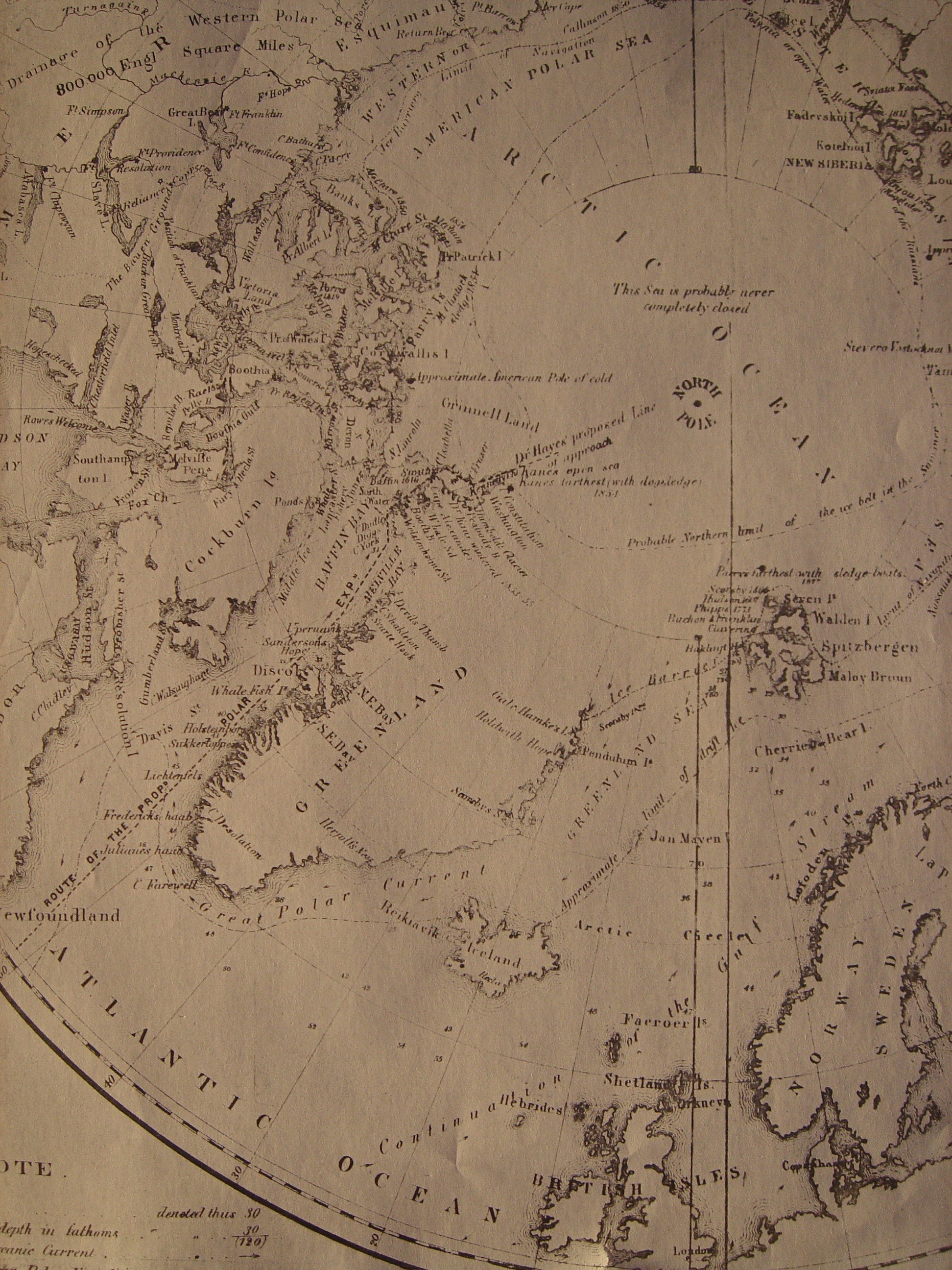
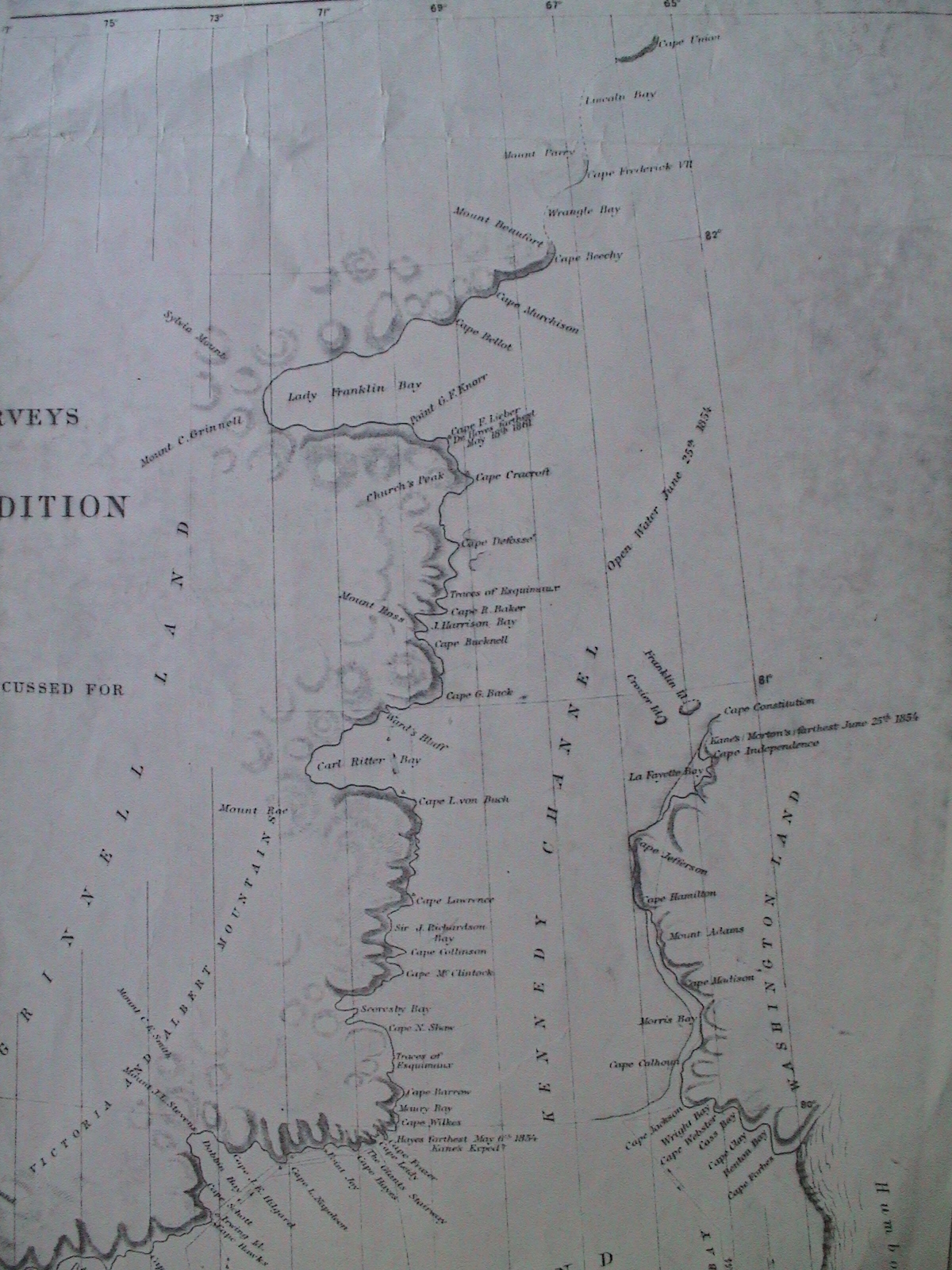
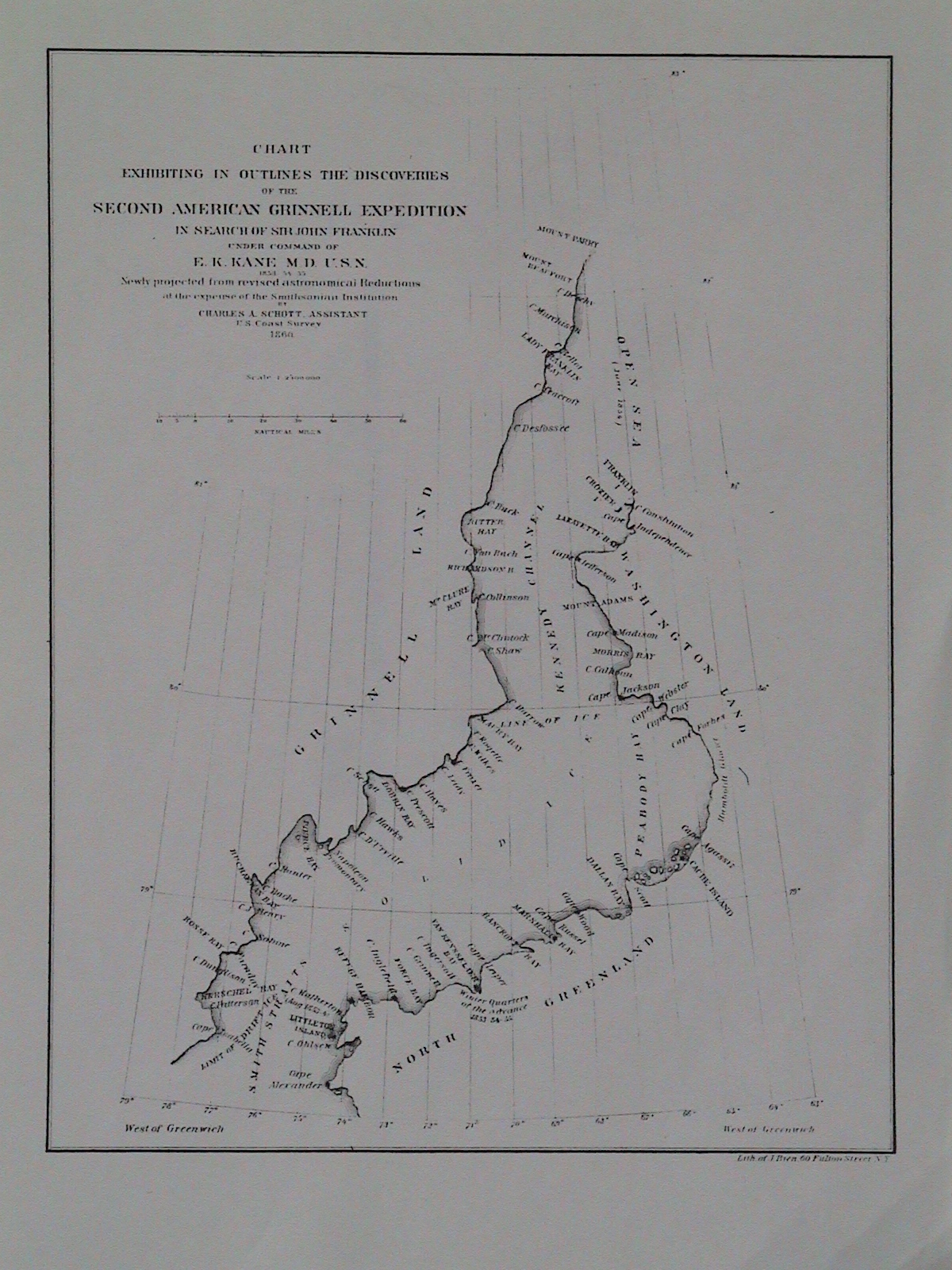
A splice
by Keith Pickering of two Canadian topo maps
for the Cape Collinson area
(north of 80°N) appears below.
By clicking on it, one accesses his splice of this with two more
Canadian topos (south of 80°N). The result provides an ultra-fine 3meg map
covering the whole Hayes 1861 Ellesmere region.
(When going to this large map, you may at first see just blank white. If so,
just zoom-out to see the whole map, before zooming-in to points of interest.
Or move down and right-ward to leave the blank-space
and arrive at Ellesmere topography. Cape Collinson
is somewhat above and to the right of the map-image's center.)
[If the large map comes up distorted, just download it
and examine it independently with appropriate software.]
On all these topos, solid blue grid lines are at intervals of 10km (5.400nmi).
These are not in general exactly N-S or E-W though near enough for rough work.
But the prominent curved line exactly marks 80°N and is always
perpendicular to precise N-S. It displays longitude by black-vs-white
hash-marks every 5' of longitude, 5' being (along 80°N) c.0.9nmi.
Notice slim black crosses (such as those on Cape Jos. Good
and near Cape Hawks) precisely oriented
to the cardinal points, to mark wherever a quarter-degree
parallel (latitude) intersects an integral-degree meridian (longitude).
Heights are indicated in feet, by brown-line contours spaced
every 500' of height above sea-level.
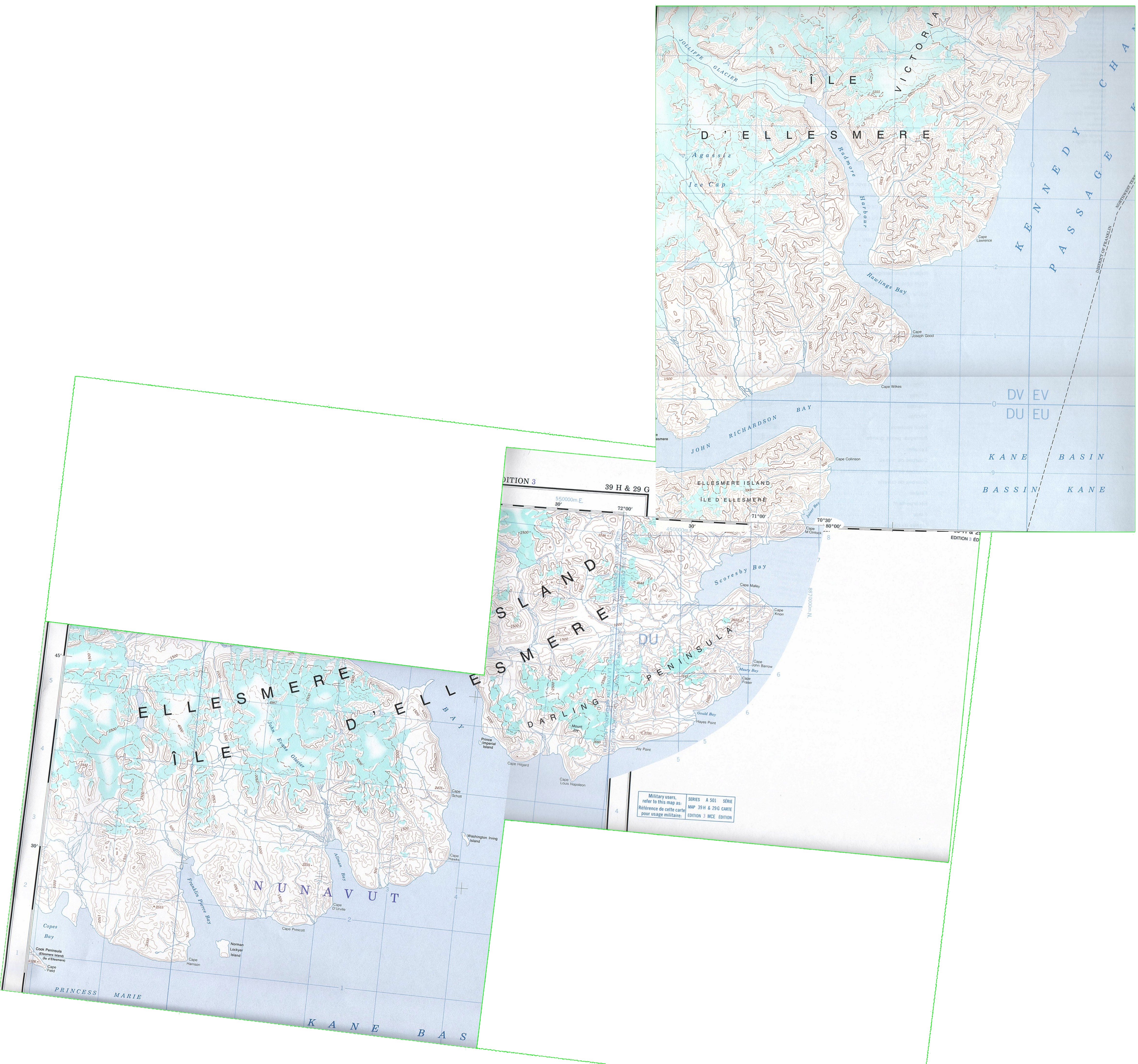
Hayes 1861 ms “Bearings” p.27 (HB27):
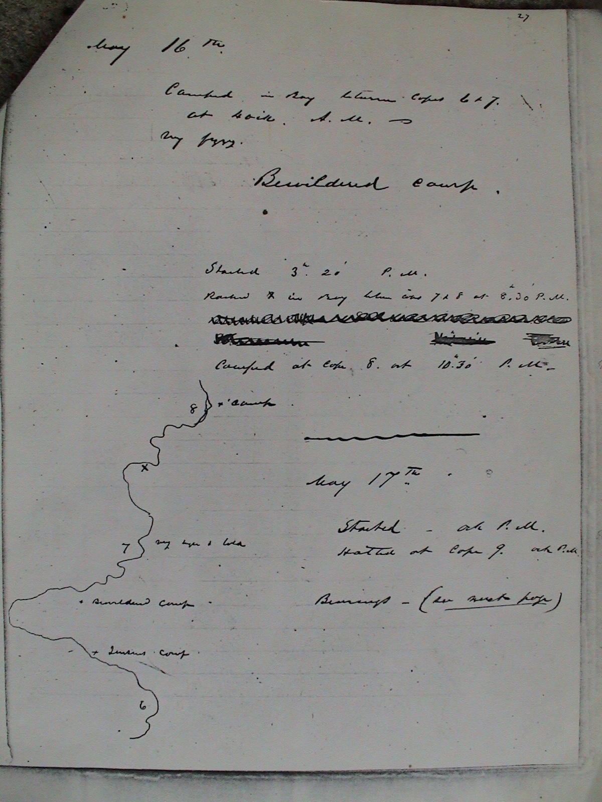
Hayes 1861 ms “Bearings” p.28 (HB28), providing
the only surviving picture of the 1861/5/17 Cape Collinson
scene, drawn upon the heights over
the disappointed Hayes' Furthest Camp (Cape 8),
80°02'N, 70°.5 W,
4nmi south of his farthest north point
(Cape 11), 80°07'N, 70°.5 W.
(Hayes was perhaps 1st to bring photography to the high arctic:
Hayes 1861 p.159. But he does not mention carrying his camera
to Cape Collinson.)
Compare the original sketch's
mountain grades to those
in his published rendition of the same view,
which is reproduced directly following HB28 here.
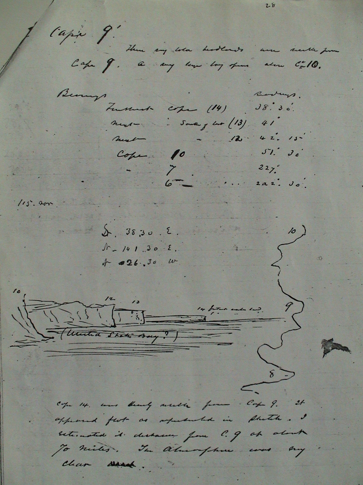
Hayes 1861 ms “Bearings” p.31 (HB31):
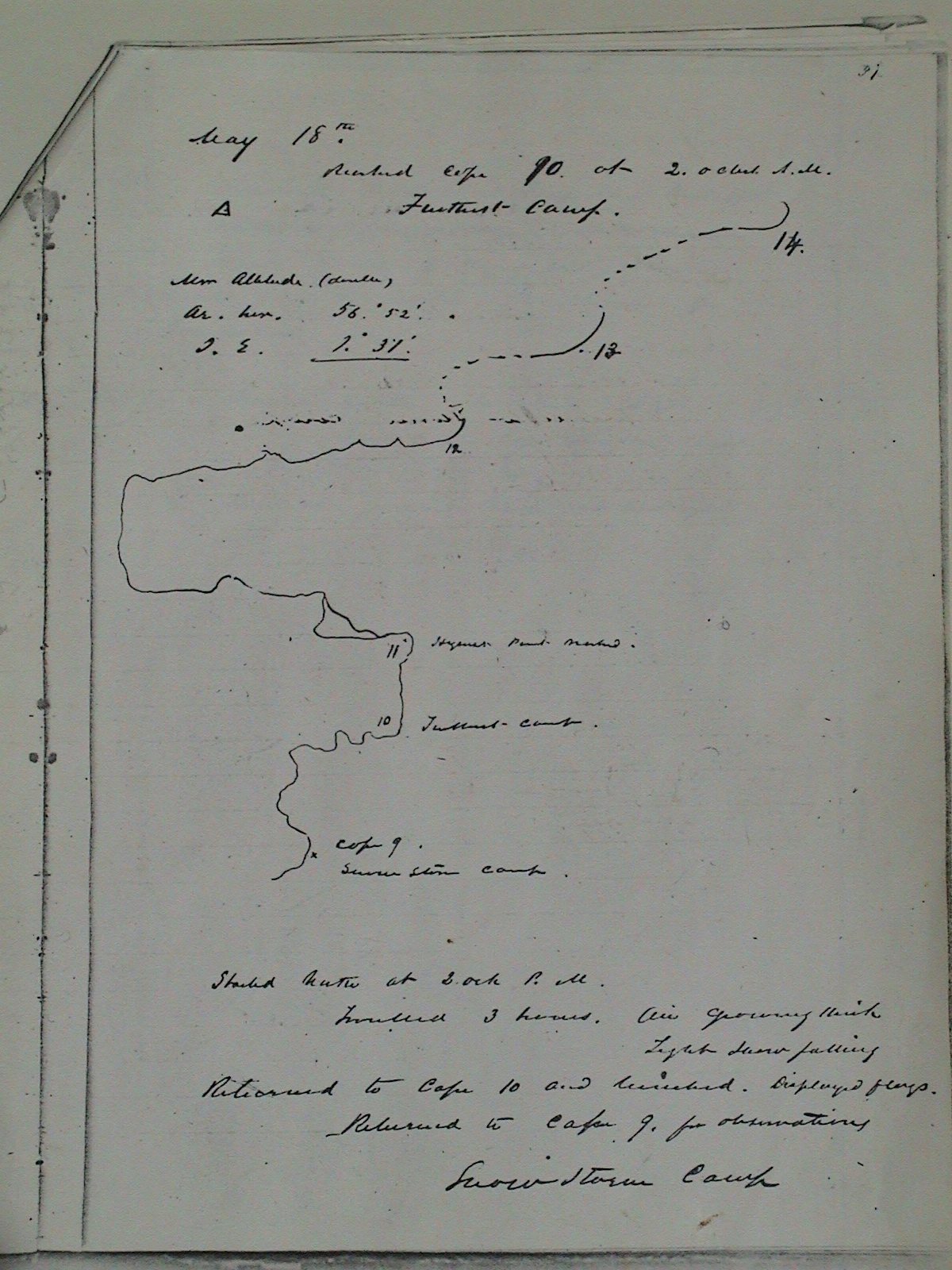
Illustration from Hayes' book, The Open Polar Sea 1867 opposite p.346 (HO346). (Compare mountain grades to original HB28 sketch, reproduced directly above. Note also shift in height-perspective.)
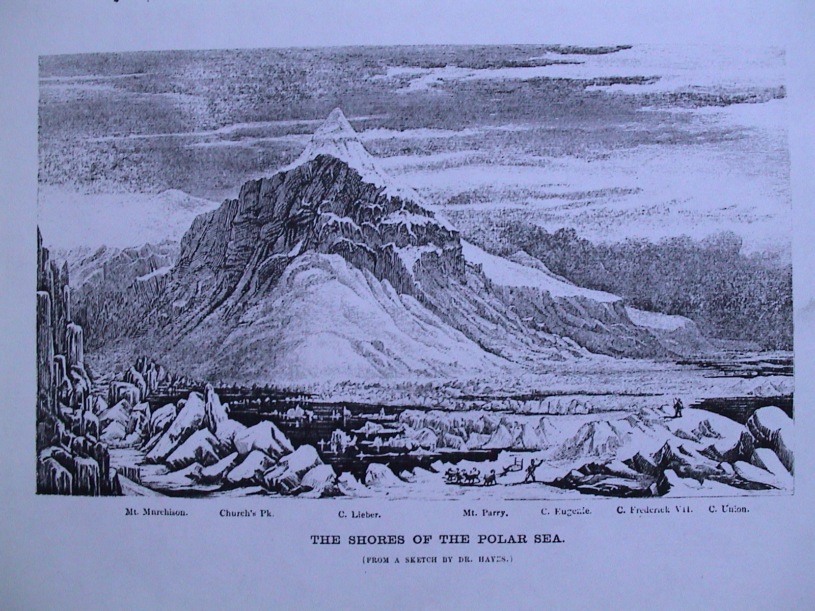
Portion of p.351 (HO351) of Hayes' book, The Open Polar Sea 1867, containing alleged 1861/5/18-19 cairn-record text:
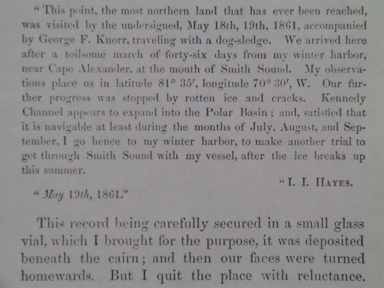
Thanks are in order to Lynn S. Mullins and to Keith A. Pickering for vital assistance in these researches.